|
|
|||||||||||||||||
| Point ID: 8809 | Downloads | Plots | Site Data | Code: 12301 |
|
|
|||||||||||||||||
| Download | |
|---|---|
| Site Descriptor Information | Site Time Series Data |
| Link to all available data | |
| View: | Time Series | All |
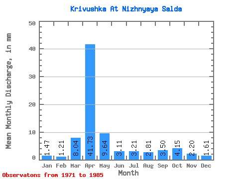
| Units: | m3/s |
| Statistic | Jan | Feb | Mar | Apr | May | Jun | Jul | Aug | Sep | Oct | Nov | Dec | Annual |
|---|---|---|---|---|---|---|---|---|---|---|---|---|---|
| Mean | 1.50 | 1.25 | 8.01 | 41.71 | 9.65 | 3.08 | 3.26 | 2.77 | 3.48 | 4.16 | 2.17 | 1.66 | 81.94 |
| Standard Deviation | 1.05 | 0.96 | 9.99 | 26.79 | 8.93 | 3.45 | 3.01 | 1.76 | 2.29 | 4.10 | 0.81 | 0.97 | 26.98 |
| Min | 0.27 | 0.24 | 0.40 | 6.74 | 2.81 | 0.78 | 0.54 | 0.67 | 1.17 | 1.47 | 0.78 | 0.27 | 46.81 |
| Max | 3.08 | 2.68 | 33.48 | 106.27 | 29.46 | 14.26 | 12.85 | 6.96 | 10.11 | 17.41 | 3.24 | 3.35 | 141.07 |
| Coefficient of Variation | 0.70 | 0.76 | 1.25 | 0.64 | 0.93 | 1.12 | 0.92 | 0.63 | 0.66 | 0.99 | 0.37 | 0.59 | 0.33 |
 Return to R-Arctic Net Home Page