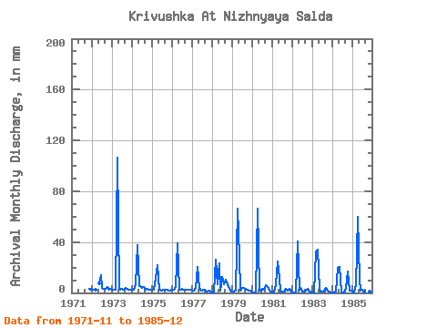
| Point ID: 8809 | Downloads | Plots | Site Data | Code: 12301 |
| Download | |
|---|---|
| Site Descriptor Information | Site Time Series Data |
| Link to all available data | |

|

|
| View: | Statistics | Time Series |
| Units: | m3/s |
| Statistic | Jan | Feb | Mar | Apr | May | Jun | Jul | Aug | Sep | Oct | Nov | Dec | Annual |
|---|---|---|---|---|---|---|---|---|---|---|---|---|---|
| Mean | 1.50 | 1.25 | 8.01 | 41.71 | 9.65 | 3.08 | 3.26 | 2.77 | 3.48 | 4.16 | 2.17 | 1.66 | 81.94 |
| Standard Deviation | 1.05 | 0.96 | 9.99 | 26.79 | 8.93 | 3.45 | 3.01 | 1.76 | 2.29 | 4.10 | 0.81 | 0.97 | 26.98 |
| Min | 0.27 | 0.24 | 0.40 | 6.74 | 2.81 | 0.78 | 0.54 | 0.67 | 1.17 | 1.47 | 0.78 | 0.27 | 46.81 |
| Max | 3.08 | 2.68 | 33.48 | 106.27 | 29.46 | 14.26 | 12.85 | 6.96 | 10.11 | 17.41 | 3.24 | 3.35 | 141.07 |
| Coefficient of Variation | 0.70 | 0.76 | 1.25 | 0.64 | 0.93 | 1.12 | 0.92 | 0.63 | 0.66 | 0.99 | 0.37 | 0.59 | 0.33 |
| Year | Jan | Feb | Mar | Apr | May | Jun | Jul | Aug | Sep | Oct | Nov | Dec | Annual | 1971 | 3.24 | 2.95 | 1972 | 3.08 | 2.68 | 2.68 | 7.63 | 14.26 | 3.75 | 3.48 | 3.24 | 4.69 | 2.85 | 3.35 | 1973 | 2.95 | 2.44 | 2.81 | 106.27 | 4.42 | 2.85 | 3.21 | 2.54 | 3.71 | 3.29 | 2.59 | 2.49 | 141.07 | 1974 | 2.81 | 2.56 | 7.18 | 37.66 | 5.22 | 5.52 | 3.88 | 4.90 | 2.72 | 3.08 | 2.72 | 2.54 | 81.19 | 1975 | 2.54 | 2.07 | 12.32 | 22.03 | 2.81 | 2.20 | 2.14 | 2.95 | 2.20 | 2.41 | 2.07 | 2.14 | 57.99 | 1976 | 2.28 | 2.07 | 5.04 | 38.88 | 3.62 | 2.20 | 3.35 | 2.89 | 2.54 | 2.49 | 2.54 | 2.36 | 70.64 | 1977 | 2.01 | 1.71 | 4.42 | 20.74 | 4.15 | 2.85 | 2.14 | 2.95 | 1.56 | 1.47 | 1.94 | 0.67 | 46.81 | 1978 | 0.54 | 0.37 | 26.78 | 6.74 | 24.10 | 2.07 | 12.85 | 6.96 | 10.11 | 7.23 | 3.11 | 1.88 | 101.65 | 1979 | 1.34 | 1.22 | 2.01 | 66.17 | 29.46 | 1.56 | 4.02 | 4.37 | 2.93 | 2.36 | 2.07 | 1.74 | 119.53 | 1980 | 0.54 | 0.37 | 0.40 | 66.17 | 3.62 | 1.17 | 3.62 | 2.41 | 6.22 | 4.55 | 1.56 | 0.80 | 92.26 | 1981 | 0.67 | 0.61 | 7.10 | 24.62 | 12.19 | 1.17 | 0.80 | 1.34 | 3.24 | 2.14 | 3.11 | 0.54 | 57.60 | 1982 | 0.54 | 0.49 | 0.40 | 40.18 | 2.95 | 3.63 | 0.94 | 0.94 | 1.56 | 3.21 | 1.43 | 1.07 | 57.86 | 1983 | 0.67 | 0.37 | 33.48 | 33.70 | 3.08 | 0.78 | 1.47 | 1.07 | 3.89 | 2.14 | 0.78 | 0.27 | 81.53 | 1984 | 0.27 | 0.24 | 1.34 | 19.44 | 21.42 | 0.78 | 0.54 | 0.67 | 3.63 | 17.41 | 1.69 | 1.61 | 68.64 | 1985 | 0.80 | 0.37 | 6.16 | 59.62 | 10.44 | 2.07 | 2.95 | 1.34 | 1.17 | 1.74 | 0.78 | 0.54 | 88.50 |
|---|
 Return to R-Arctic Net Home Page