|
|
|||||||||||||||||
| Point ID: 875 | Downloads | Plots | Site Data | Code: 07FA001 |
|
|
|||||||||||||||||
| Download | |
|---|---|
| Site Descriptor Information | Site Time Series Data |
| Link to all available data | |
| View: | Time Series | All |
| Units: | m3/s |
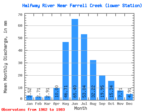
| Statistic | Jan | Feb | Mar | Apr | May | Jun | Jul | Aug | Sep | Oct | Nov | Dec | Annual |
|---|---|---|---|---|---|---|---|---|---|---|---|---|---|
| Mean | 3.52 | 2.73 | 2.91 | 10.00 | 46.70 | 65.40 | 53.04 | 32.21 | 19.95 | 15.34 | 7.71 | 4.91 | 253.38 |
| Standard Deviation | 1.14 | 0.93 | 0.85 | 7.69 | 26.89 | 18.85 | 25.91 | 36.83 | 10.24 | 8.19 | 3.05 | 1.51 | 80.26 |
| Min | 1.54 | 0.81 | 0.76 | 3.12 | 10.65 | 39.43 | 18.26 | 11.37 | 7.36 | 5.04 | 2.81 | 2.23 | 143.71 |
| Max | 5.75 | 4.65 | 4.36 | 37.23 | 120.22 | 108.09 | 117.09 | 182.05 | 46.05 | 34.47 | 14.70 | 8.06 | 436.72 |
| Coefficient of Variation | 0.32 | 0.34 | 0.29 | 0.77 | 0.58 | 0.29 | 0.49 | 1.14 | 0.51 | 0.53 | 0.40 | 0.31 | 0.32 |
 Return to R-Arctic Net Home Page