|
|
|||||||||||||||||
| Point ID: 875 | Downloads | Plots | Site Data | Code: 07FA001 |
|
|
|||||||||||||||||
| Download | |
|---|---|
| Site Descriptor Information | Site Time Series Data |
| Link to all available data | |
| View: | Time Series | All |
| Units: | mm |
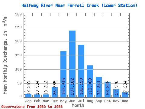
| Statistic | Jan | Feb | Mar | Apr | May | Jun | Jul | Aug | Sep | Oct | Nov | Dec | Annual |
|---|---|---|---|---|---|---|---|---|---|---|---|---|---|
| Mean | 12.37 | 10.53 | 10.21 | 36.26 | 163.91 | 237.18 | 186.16 | 113.07 | 72.34 | 53.84 | 27.98 | 17.23 | 75.47 |
| Standard Deviation | 4.00 | 3.58 | 2.99 | 27.87 | 94.38 | 68.35 | 90.94 | 129.27 | 37.14 | 28.75 | 11.05 | 5.30 | 23.90 |
| Min | 5.39 | 3.11 | 2.65 | 11.30 | 37.40 | 143.00 | 64.10 | 39.90 | 26.70 | 17.70 | 10.20 | 7.81 | 42.80 |
| Max | 20.20 | 17.90 | 15.30 | 135.00 | 422.00 | 392.00 | 411.00 | 639.00 | 167.00 | 121.00 | 53.30 | 28.30 | 130.08 |
| Coefficient of Variation | 0.32 | 0.34 | 0.29 | 0.77 | 0.58 | 0.29 | 0.49 | 1.14 | 0.51 | 0.53 | 0.40 | 0.31 | 0.32 |
 Return to R-Arctic Net Home Page