|
|
|||||||||||||||||
| Point ID: 8735 | Downloads | Plots | Site Data | Code: 12620 |
|
|
|||||||||||||||||
| Download | |
|---|---|
| Site Descriptor Information | Site Time Series Data |
| Link to all available data | |
| View: | Time Series | All |
| Units: | m3/s |
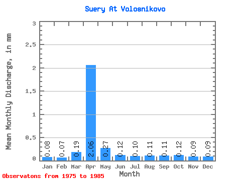
| Statistic | Jan | Feb | Mar | Apr | May | Jun | Jul | Aug | Sep | Oct | Nov | Dec | Annual |
|---|---|---|---|---|---|---|---|---|---|---|---|---|---|
| Mean | 0.08 | 0.07 | 0.18 | 2.06 | 0.27 | 0.12 | 0.10 | 0.11 | 0.10 | 0.12 | 0.09 | 0.09 | 3.41 |
| Standard Deviation | 0.03 | 0.02 | 0.30 | 1.56 | 0.15 | 0.08 | 0.03 | 0.03 | 0.03 | 0.05 | 0.02 | 0.02 | 1.72 |
| Min | 0.02 | 0.01 | 0.06 | 0.54 | 0.15 | 0.06 | 0.06 | 0.06 | 0.06 | 0.06 | 0.06 | 0.05 | 1.54 |
| Max | 0.12 | 0.10 | 1.09 | 6.07 | 0.69 | 0.35 | 0.16 | 0.17 | 0.15 | 0.24 | 0.13 | 0.12 | 7.28 |
| Coefficient of Variation | 0.34 | 0.33 | 1.63 | 0.76 | 0.56 | 0.69 | 0.33 | 0.27 | 0.24 | 0.41 | 0.24 | 0.26 | 0.50 |
 Return to R-Arctic Net Home Page