|
|
|||||||||||||||||
| Point ID: 8735 | Downloads | Plots | Site Data | Code: 12620 |
|
|
|||||||||||||||||
| Download | |
|---|---|
| Site Descriptor Information | Site Time Series Data |
| Link to all available data | |
| View: | Time Series | All |
| Units: | mm |
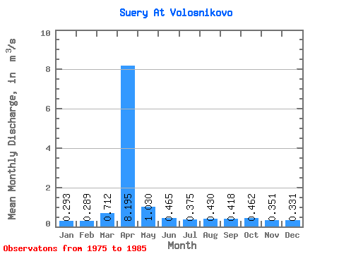
| Statistic | Jan | Feb | Mar | Apr | May | Jun | Jul | Aug | Sep | Oct | Nov | Dec | Annual |
|---|---|---|---|---|---|---|---|---|---|---|---|---|---|
| Mean | 0.29 | 0.29 | 0.71 | 8.20 | 1.03 | 0.47 | 0.38 | 0.43 | 0.42 | 0.46 | 0.35 | 0.33 | 1.11 |
| Standard Deviation | 0.10 | 0.10 | 1.16 | 6.21 | 0.58 | 0.32 | 0.12 | 0.11 | 0.10 | 0.19 | 0.09 | 0.09 | 0.56 |
| Min | 0.07 | 0.06 | 0.21 | 2.15 | 0.59 | 0.24 | 0.23 | 0.23 | 0.24 | 0.22 | 0.25 | 0.20 | 0.50 |
| Max | 0.46 | 0.41 | 4.18 | 24.10 | 2.65 | 1.38 | 0.60 | 0.66 | 0.61 | 0.93 | 0.51 | 0.47 | 2.38 |
| Coefficient of Variation | 0.34 | 0.33 | 1.63 | 0.76 | 0.56 | 0.69 | 0.33 | 0.27 | 0.24 | 0.41 | 0.24 | 0.26 | 0.50 |
 Return to R-Arctic Net Home Page