|
|
|||||||||||||||||
| Point ID: 8706 | Downloads | Plots | Site Data | Code: 11671 |
|
|
|||||||||||||||||
| Download | |
|---|---|
| Site Descriptor Information | Site Time Series Data |
| Link to all available data | |
| View: | Time Series | All |
| Units: | m3/s |
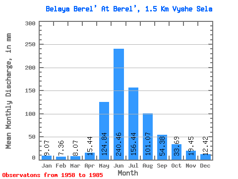
| Statistic | Jan | Feb | Mar | Apr | May | Jun | Jul | Aug | Sep | Oct | Nov | Dec | Annual |
|---|---|---|---|---|---|---|---|---|---|---|---|---|---|
| Mean | 9.07 | 7.43 | 8.07 | 15.44 | 124.82 | 240.46 | 156.42 | 101.05 | 54.39 | 33.69 | 19.45 | 12.42 | 780.13 |
| Standard Deviation | 1.68 | 1.61 | 1.82 | 6.54 | 45.38 | 82.70 | 62.45 | 32.97 | 13.76 | 10.79 | 5.73 | 3.30 | 163.14 |
| Min | 6.41 | 4.34 | 4.61 | 5.98 | 17.48 | 99.94 | 69.01 | 55.62 | 25.42 | 17.64 | 9.70 | 7.18 | 482.81 |
| Max | 13.75 | 10.21 | 11.25 | 37.88 | 216.04 | 436.15 | 321.88 | 168.41 | 75.52 | 54.59 | 32.15 | 20.65 | 1090.31 |
| Coefficient of Variation | 0.18 | 0.22 | 0.23 | 0.42 | 0.36 | 0.34 | 0.40 | 0.33 | 0.25 | 0.32 | 0.29 | 0.27 | 0.21 |
 Return to R-Arctic Net Home Page