|
|
|||||||||||||||||
| Point ID: 8706 | Downloads | Plots | Site Data | Code: 11671 |
|
|
|||||||||||||||||
| Download | |
|---|---|
| Site Descriptor Information | Site Time Series Data |
| Link to all available data | |
| View: | Time Series | All |
| Units: | mm |
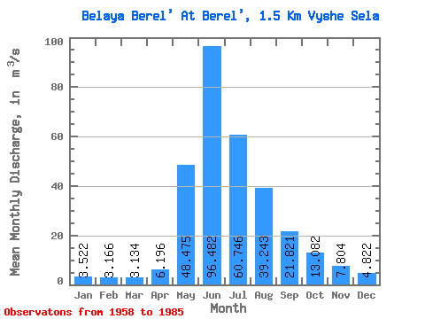
| Statistic | Jan | Feb | Mar | Apr | May | Jun | Jul | Aug | Sep | Oct | Nov | Dec | Annual |
|---|---|---|---|---|---|---|---|---|---|---|---|---|---|
| Mean | 3.52 | 3.17 | 3.13 | 6.20 | 48.48 | 96.48 | 60.75 | 39.24 | 21.82 | 13.08 | 7.80 | 4.82 | 25.71 |
| Standard Deviation | 0.65 | 0.69 | 0.70 | 2.62 | 17.62 | 33.18 | 24.25 | 12.80 | 5.52 | 4.19 | 2.30 | 1.28 | 5.38 |
| Min | 2.49 | 1.85 | 1.79 | 2.40 | 6.79 | 40.10 | 26.80 | 21.60 | 10.20 | 6.85 | 3.89 | 2.79 | 15.91 |
| Max | 5.34 | 4.35 | 4.37 | 15.20 | 83.90 | 175.00 | 125.00 | 65.40 | 30.30 | 21.20 | 12.90 | 8.02 | 35.93 |
| Coefficient of Variation | 0.18 | 0.22 | 0.23 | 0.42 | 0.36 | 0.34 | 0.40 | 0.33 | 0.25 | 0.32 | 0.29 | 0.27 | 0.21 |
 Return to R-Arctic Net Home Page