|
|
|||||||||||||||||
| Point ID: 8672 | Downloads | Plots | Site Data | Code: 11553 |
|
|
|||||||||||||||||
| Download | |
|---|---|
| Site Descriptor Information | Site Time Series Data |
| Link to all available data | |
| View: | Time Series | All |
| Units: | m3/s |
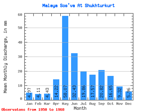
| Statistic | Jan | Feb | Mar | Apr | May | Jun | Jul | Aug | Sep | Oct | Nov | Dec | Annual |
|---|---|---|---|---|---|---|---|---|---|---|---|---|---|
| Mean | 4.97 | 4.14 | 4.43 | 14.22 | 58.06 | 32.43 | 19.86 | 17.57 | 20.82 | 16.65 | 9.31 | 5.96 | 195.55 |
| Standard Deviation | 0.88 | 0.61 | 0.65 | 11.69 | 22.90 | 13.52 | 12.81 | 23.41 | 24.36 | 8.04 | 3.00 | 1.28 | 34.34 |
| Min | 3.47 | 3.46 | 3.62 | 3.86 | 24.61 | 14.51 | 9.03 | 6.46 | 7.26 | 7.72 | 5.55 | 4.29 | 128.02 |
| Max | 6.91 | 5.76 | 6.10 | 41.31 | 98.45 | 67.31 | 58.71 | 107.93 | 114.96 | 32.20 | 15.91 | 9.30 | 243.29 |
| Coefficient of Variation | 0.18 | 0.15 | 0.15 | 0.82 | 0.39 | 0.42 | 0.65 | 1.33 | 1.17 | 0.48 | 0.32 | 0.21 | 0.18 |
 Return to R-Arctic Net Home Page