|
|
|||||||||||||||||
| Point ID: 8672 | Downloads | Plots | Site Data | Code: 11553 |
|
|
|||||||||||||||||
| Download | |
|---|---|
| Site Descriptor Information | Site Time Series Data |
| Link to all available data | |
| View: | Time Series | All |
| Units: | mm |
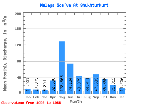
| Statistic | Jan | Feb | Mar | Apr | May | Jun | Jul | Aug | Sep | Oct | Nov | Dec | Annual |
|---|---|---|---|---|---|---|---|---|---|---|---|---|---|
| Mean | 11.01 | 10.07 | 9.80 | 32.53 | 128.56 | 74.18 | 43.98 | 38.91 | 47.63 | 36.87 | 21.31 | 13.21 | 36.74 |
| Standard Deviation | 1.94 | 1.48 | 1.45 | 26.73 | 50.72 | 30.94 | 28.37 | 51.85 | 55.74 | 17.79 | 6.86 | 2.83 | 6.45 |
| Min | 7.69 | 8.42 | 8.02 | 8.84 | 54.50 | 33.20 | 20.00 | 14.30 | 16.60 | 17.10 | 12.70 | 9.51 | 24.05 |
| Max | 15.30 | 14.00 | 13.50 | 94.50 | 218.00 | 154.00 | 130.00 | 239.00 | 263.00 | 71.30 | 36.40 | 20.60 | 45.71 |
| Coefficient of Variation | 0.18 | 0.15 | 0.15 | 0.82 | 0.39 | 0.42 | 0.65 | 1.33 | 1.17 | 0.48 | 0.32 | 0.21 | 0.18 |
 Return to R-Arctic Net Home Page