|
|
|||||||||||||||||
| Point ID: 8664 | Downloads | Plots | Site Data | Code: 11503 |
|
|
|||||||||||||||||
| Download | |
|---|---|
| Site Descriptor Information | Site Time Series Data |
| Link to all available data | |
| View: | Time Series | All |
| Units: | m3/s |
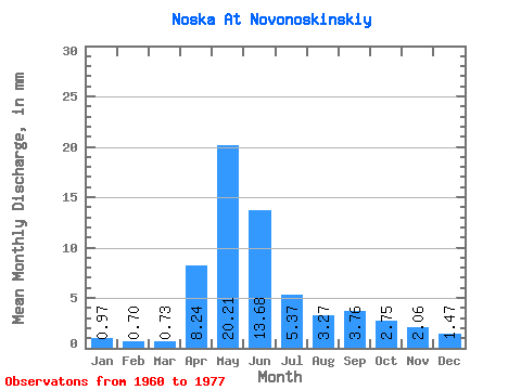
| Statistic | Jan | Feb | Mar | Apr | May | Jun | Jul | Aug | Sep | Oct | Nov | Dec | Annual |
|---|---|---|---|---|---|---|---|---|---|---|---|---|---|
| Mean | 0.97 | 0.70 | 0.73 | 8.24 | 20.21 | 13.68 | 5.37 | 3.27 | 3.76 | 2.75 | 2.06 | 1.47 | 60.46 |
| Standard Deviation | 0.47 | 0.27 | 0.20 | 5.25 | 12.28 | 13.18 | 4.49 | 2.62 | 4.04 | 2.68 | 1.29 | 0.93 | 35.22 |
| Min | 0.42 | 0.33 | 0.40 | 1.27 | 4.29 | 2.88 | 1.25 | 0.71 | 0.49 | 0.40 | 0.45 | 0.37 | 17.72 |
| Max | 2.21 | 1.36 | 1.17 | 16.97 | 43.91 | 51.52 | 17.20 | 11.61 | 17.23 | 11.51 | 4.48 | 3.73 | 139.18 |
| Coefficient of Variation | 0.48 | 0.39 | 0.28 | 0.64 | 0.61 | 0.96 | 0.84 | 0.80 | 1.07 | 0.97 | 0.63 | 0.64 | 0.58 |
 Return to R-Arctic Net Home Page