|
|
|||||||||||||||||
| Point ID: 8664 | Downloads | Plots | Site Data | Code: 11503 |
|
|
|||||||||||||||||
| Download | |
|---|---|
| Site Descriptor Information | Site Time Series Data |
| Link to all available data | |
| View: | Time Series | All |
| Units: | mm |
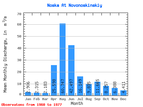
| Statistic | Jan | Feb | Mar | Apr | May | Jun | Jul | Aug | Sep | Oct | Nov | Dec | Annual |
|---|---|---|---|---|---|---|---|---|---|---|---|---|---|
| Mean | 2.91 | 2.31 | 2.18 | 25.60 | 60.75 | 42.50 | 16.15 | 9.84 | 11.66 | 8.26 | 6.39 | 4.41 | 15.42 |
| Standard Deviation | 1.40 | 0.89 | 0.60 | 16.32 | 36.92 | 40.92 | 13.51 | 7.86 | 12.54 | 8.05 | 4.00 | 2.80 | 8.98 |
| Min | 1.27 | 1.09 | 1.21 | 3.94 | 12.90 | 8.95 | 3.76 | 2.13 | 1.53 | 1.20 | 1.41 | 1.11 | 4.52 |
| Max | 6.63 | 4.49 | 3.51 | 52.70 | 132.00 | 160.00 | 51.70 | 34.90 | 53.50 | 34.60 | 13.90 | 11.20 | 35.50 |
| Coefficient of Variation | 0.48 | 0.39 | 0.28 | 0.64 | 0.61 | 0.96 | 0.84 | 0.80 | 1.07 | 0.97 | 0.63 | 0.64 | 0.58 |
 Return to R-Arctic Net Home Page