|
|
|||||||||||||||||
| Point ID: 864 | Downloads | Plots | Site Data | Code: 07ED001 |
|
|
|||||||||||||||||
| Download | |
|---|---|
| Site Descriptor Information | Site Time Series Data |
| Link to all available data | |
| View: | Time Series | All |
| Units: | m3/s |
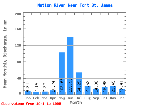
| Statistic | Jan | Feb | Mar | Apr | May | Jun | Jul | Aug | Sep | Oct | Nov | Dec | Annual |
|---|---|---|---|---|---|---|---|---|---|---|---|---|---|
| Mean | 9.84 | 7.21 | 7.21 | 10.74 | 102.67 | 139.93 | 54.24 | 21.53 | 14.06 | 18.97 | 21.45 | 13.91 | 412.45 |
| Standard Deviation | 2.50 | 1.48 | 1.66 | 5.90 | 31.69 | 47.71 | 20.69 | 10.79 | 7.54 | 13.22 | 17.43 | 5.92 | 80.77 |
| Min | 5.38 | 4.89 | 4.88 | 5.33 | 47.22 | 51.01 | 26.16 | 9.17 | 4.95 | 5.09 | 6.67 | 5.19 | 259.54 |
| Max | 15.76 | 10.71 | 12.37 | 38.91 | 160.06 | 303.29 | 106.50 | 60.82 | 39.68 | 89.88 | 112.02 | 33.55 | 588.88 |
| Coefficient of Variation | 0.25 | 0.21 | 0.23 | 0.55 | 0.31 | 0.34 | 0.38 | 0.50 | 0.54 | 0.70 | 0.81 | 0.43 | 0.20 |
 Return to R-Arctic Net Home Page