|
|
|||||||||||||||||
| Point ID: 864 | Downloads | Plots | Site Data | Code: 07ED001 |
|
|
|||||||||||||||||
| Download | |
|---|---|
| Site Descriptor Information | Site Time Series Data |
| Link to all available data | |
| View: | Time Series | All |
| Units: | mm |
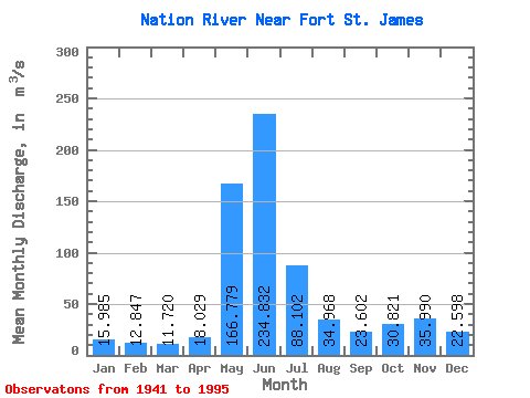
| Statistic | Jan | Feb | Mar | Apr | May | Jun | Jul | Aug | Sep | Oct | Nov | Dec | Annual |
|---|---|---|---|---|---|---|---|---|---|---|---|---|---|
| Mean | 15.98 | 12.85 | 11.72 | 18.03 | 166.78 | 234.83 | 88.10 | 34.97 | 23.60 | 30.82 | 35.99 | 22.60 | 56.85 |
| Standard Deviation | 4.06 | 2.65 | 2.69 | 9.89 | 51.48 | 80.06 | 33.61 | 17.53 | 12.65 | 21.48 | 29.25 | 9.62 | 11.13 |
| Min | 8.74 | 8.71 | 7.93 | 8.94 | 76.70 | 85.60 | 42.50 | 14.90 | 8.31 | 8.27 | 11.20 | 8.43 | 35.77 |
| Max | 25.60 | 19.10 | 20.10 | 65.30 | 260.00 | 509.00 | 173.00 | 98.80 | 66.60 | 146.00 | 188.00 | 54.50 | 81.17 |
| Coefficient of Variation | 0.25 | 0.21 | 0.23 | 0.55 | 0.31 | 0.34 | 0.38 | 0.50 | 0.54 | 0.70 | 0.81 | 0.43 | 0.20 |
 Return to R-Arctic Net Home Page