|
|
|||||||||||||||||
| Point ID: 863 | Downloads | Plots | Site Data | Code: 07EC004 |
|
|
|||||||||||||||||
| Download | |
|---|---|
| Site Descriptor Information | Site Time Series Data |
| Link to all available data | |
| View: | Time Series | All |
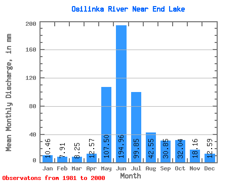
| Units: | m3/s |
| Statistic | Jan | Feb | Mar | Apr | May | Jun | Jul | Aug | Sep | Oct | Nov | Dec | Annual |
|---|---|---|---|---|---|---|---|---|---|---|---|---|---|
| Mean | 10.46 | 7.98 | 8.25 | 12.57 | 107.49 | 194.96 | 99.84 | 42.54 | 30.85 | 32.03 | 18.16 | 12.58 | 576.47 |
| Standard Deviation | 1.93 | 1.09 | 0.90 | 4.38 | 43.28 | 48.45 | 30.47 | 10.84 | 8.65 | 11.54 | 4.71 | 2.51 | 69.76 |
| Min | 7.06 | 6.41 | 6.80 | 7.05 | 44.41 | 115.05 | 46.05 | 25.28 | 17.72 | 12.84 | 9.65 | 6.98 | 491.90 |
| Max | 14.89 | 9.62 | 10.47 | 27.77 | 199.48 | 284.33 | 184.45 | 67.50 | 49.72 | 59.16 | 28.43 | 16.81 | 733.21 |
| Coefficient of Variation | 0.18 | 0.14 | 0.11 | 0.35 | 0.40 | 0.25 | 0.30 | 0.26 | 0.28 | 0.36 | 0.26 | 0.20 | 0.12 |
 Return to R-Arctic Net Home Page