|
|
|||||||||||||||||
| Point ID: 863 | Downloads | Plots | Site Data | Code: 07EC004 |
|
|
|||||||||||||||||
| Download | |
|---|---|
| Site Descriptor Information | Site Time Series Data |
| Link to all available data | |
| View: | Time Series | All |
| Units: | mm |
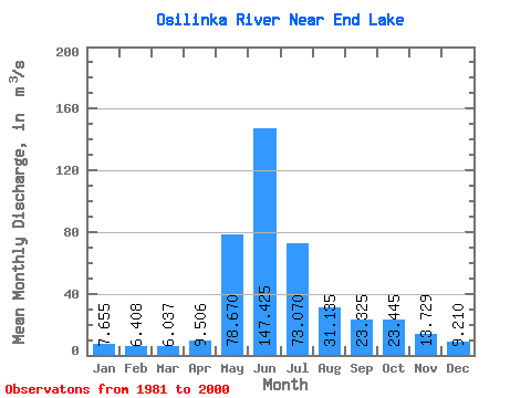
| Statistic | Jan | Feb | Mar | Apr | May | Jun | Jul | Aug | Sep | Oct | Nov | Dec | Annual |
|---|---|---|---|---|---|---|---|---|---|---|---|---|---|
| Mean | 7.66 | 6.41 | 6.04 | 9.51 | 78.67 | 147.43 | 73.07 | 31.14 | 23.32 | 23.45 | 13.73 | 9.21 | 35.80 |
| Standard Deviation | 1.42 | 0.87 | 0.66 | 3.31 | 31.67 | 36.64 | 22.30 | 7.94 | 6.54 | 8.44 | 3.56 | 1.84 | 4.33 |
| Min | 5.17 | 5.15 | 4.98 | 5.33 | 32.50 | 87.00 | 33.70 | 18.50 | 13.40 | 9.40 | 7.30 | 5.11 | 30.55 |
| Max | 10.90 | 7.73 | 7.66 | 21.00 | 146.00 | 215.00 | 135.00 | 49.40 | 37.60 | 43.30 | 21.50 | 12.30 | 45.53 |
| Coefficient of Variation | 0.18 | 0.14 | 0.11 | 0.35 | 0.40 | 0.25 | 0.30 | 0.26 | 0.28 | 0.36 | 0.26 | 0.20 | 0.12 |
 Return to R-Arctic Net Home Page