|
|
|||||||||||||||||
| Point ID: 8605 | Downloads | Plots | Site Data | Code: 11216 |
|
|
|||||||||||||||||
| Download | |
|---|---|
| Site Descriptor Information | Site Time Series Data |
| Link to all available data | |
| View: | Time Series | All |
| Units: | m3/s |
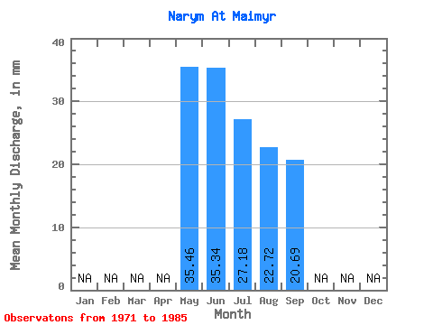
| Statistic | Jan | Feb | Mar | Apr | May | Jun | Jul | Aug | Sep | Oct | Nov | Dec | Annual |
|---|---|---|---|---|---|---|---|---|---|---|---|---|---|
| Mean | 35.46 | 35.34 | 27.17 | 22.71 | 20.69 | ||||||||
| Standard Deviation | 21.30 | 21.16 | 17.21 | 12.07 | 8.71 | ||||||||
| Min | 18.52 | 6.93 | 9.26 | 9.92 | 10.56 | ||||||||
| Max | 97.53 | 95.47 | 69.43 | 50.20 | 40.80 | ||||||||
| Coefficient of Variation | 0.60 | 0.60 | 0.63 | 0.53 | 0.42 |
 Return to R-Arctic Net Home Page