|
|
|||||||||||||||||
| Point ID: 8605 | Downloads | Plots | Site Data | Code: 11216 |
|
|
|||||||||||||||||
| Download | |
|---|---|
| Site Descriptor Information | Site Time Series Data |
| Link to all available data | |
| View: | Time Series | All |
| Units: | mm |
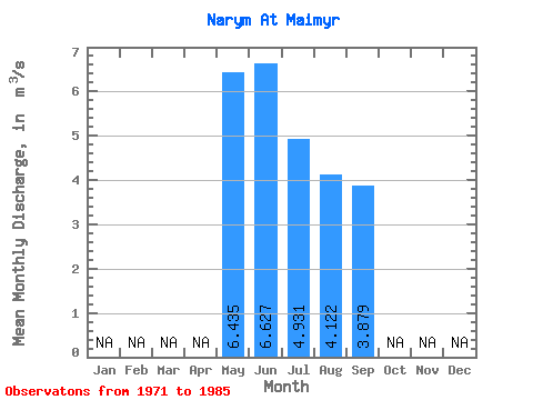
| Statistic | Jan | Feb | Mar | Apr | May | Jun | Jul | Aug | Sep | Oct | Nov | Dec | Annual |
|---|---|---|---|---|---|---|---|---|---|---|---|---|---|
| Mean | 6.43 | 6.63 | 4.93 | 4.12 | 3.88 | ||||||||
| Standard Deviation | 3.87 | 3.97 | 3.12 | 2.19 | 1.63 | ||||||||
| Min | 3.36 | 1.30 | 1.68 | 1.80 | 1.98 | ||||||||
| Max | 17.70 | 17.90 | 12.60 | 9.11 | 7.65 | ||||||||
| Coefficient of Variation | 0.60 | 0.60 | 0.63 | 0.53 | 0.42 |
 Return to R-Arctic Net Home Page