|
|
|||||||||||||||||
| Point ID: 8505 | Downloads | Plots | Site Data | Code: 10463 |
|
|
|||||||||||||||||
| Download | |
|---|---|
| Site Descriptor Information | Site Time Series Data |
| Link to all available data | |
| View: | Time Series | All |
| Units: | m3/s |
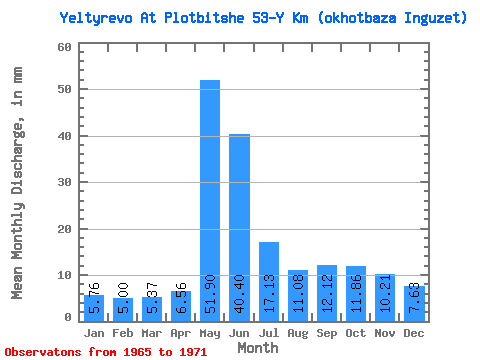
| Statistic | Jan | Feb | Mar | Apr | May | Jun | Jul | Aug | Sep | Oct | Nov | Dec | Annual |
|---|---|---|---|---|---|---|---|---|---|---|---|---|---|
| Mean | 5.76 | 5.04 | 5.37 | 6.56 | 51.90 | 40.40 | 17.13 | 11.08 | 12.12 | 11.86 | 10.21 | 7.62 | 184.48 |
| Standard Deviation | 0.63 | 0.68 | 0.72 | 3.79 | 19.80 | 20.74 | 5.99 | 2.74 | 6.97 | 8.23 | 8.00 | 3.65 | 59.62 |
| Min | 5.11 | 4.26 | 4.52 | 0.59 | 28.09 | 15.17 | 9.80 | 7.51 | 6.06 | 5.66 | 5.32 | 5.04 | 127.91 |
| Max | 6.75 | 6.00 | 6.31 | 13.01 | 80.01 | 68.49 | 27.98 | 14.15 | 25.45 | 29.23 | 28.03 | 15.62 | 306.62 |
| Coefficient of Variation | 0.11 | 0.14 | 0.13 | 0.58 | 0.38 | 0.51 | 0.35 | 0.25 | 0.58 | 0.69 | 0.78 | 0.48 | 0.32 |
 Return to R-Arctic Net Home Page