|
|
|||||||||||||||||
| Point ID: 8505 | Downloads | Plots | Site Data | Code: 10463 |
|
|
|||||||||||||||||
| Download | |
|---|---|
| Site Descriptor Information | Site Time Series Data |
| Link to all available data | |
| View: | Time Series | All |
| Units: | mm |
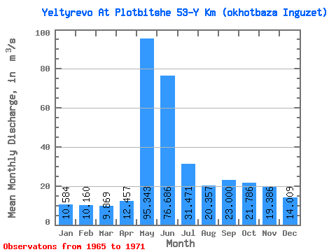
| Statistic | Jan | Feb | Mar | Apr | May | Jun | Jul | Aug | Sep | Oct | Nov | Dec | Annual |
|---|---|---|---|---|---|---|---|---|---|---|---|---|---|
| Mean | 10.58 | 10.16 | 9.87 | 12.46 | 95.34 | 76.69 | 31.47 | 20.36 | 23.00 | 21.79 | 19.39 | 14.01 | 28.76 |
| Standard Deviation | 1.16 | 1.37 | 1.33 | 7.20 | 36.37 | 39.38 | 11.00 | 5.03 | 13.24 | 15.12 | 15.19 | 6.70 | 9.29 |
| Min | 9.38 | 8.59 | 8.31 | 1.12 | 51.60 | 28.80 | 18.00 | 13.80 | 11.50 | 10.40 | 10.10 | 9.26 | 19.94 |
| Max | 12.40 | 12.10 | 11.60 | 24.70 | 147.00 | 130.00 | 51.40 | 26.00 | 48.30 | 53.70 | 53.20 | 28.70 | 47.80 |
| Coefficient of Variation | 0.11 | 0.14 | 0.13 | 0.58 | 0.38 | 0.51 | 0.35 | 0.25 | 0.58 | 0.69 | 0.78 | 0.48 | 0.32 |
 Return to R-Arctic Net Home Page