|
|
|||||||||||||||||
| Point ID: 8497 | Downloads | Plots | Site Data | Code: 10409 |
|
|
|||||||||||||||||
| Download | |
|---|---|
| Site Descriptor Information | Site Time Series Data |
| Link to all available data | |
| View: | Time Series | All |
| Units: | m3/s |
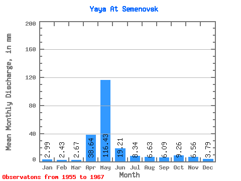
| Statistic | Jan | Feb | Mar | Apr | May | Jun | Jul | Aug | Sep | Oct | Nov | Dec | Annual |
|---|---|---|---|---|---|---|---|---|---|---|---|---|---|
| Mean | 2.99 | 2.45 | 2.67 | 38.64 | 116.42 | 19.20 | 8.34 | 6.62 | 6.09 | 9.26 | 6.56 | 3.79 | 226.84 |
| Standard Deviation | 0.71 | 0.44 | 0.45 | 30.62 | 45.23 | 12.07 | 4.03 | 3.08 | 2.88 | 5.41 | 2.95 | 1.24 | 44.53 |
| Min | 1.83 | 1.82 | 2.00 | 5.41 | 45.64 | 7.26 | 4.03 | 3.03 | 2.79 | 3.03 | 2.84 | 2.23 | 176.00 |
| Max | 4.31 | 3.08 | 3.40 | 123.74 | 181.64 | 51.84 | 14.79 | 13.53 | 13.57 | 21.59 | 11.54 | 6.89 | 319.92 |
| Coefficient of Variation | 0.24 | 0.18 | 0.17 | 0.79 | 0.39 | 0.63 | 0.48 | 0.47 | 0.47 | 0.58 | 0.45 | 0.33 | 0.20 |
 Return to R-Arctic Net Home Page