|
|
|||||||||||||||||
| Point ID: 8497 | Downloads | Plots | Site Data | Code: 10409 |
|
|
|||||||||||||||||
| Download | |
|---|---|
| Site Descriptor Information | Site Time Series Data |
| Link to all available data | |
| View: | Time Series | All |
| Units: | mm |
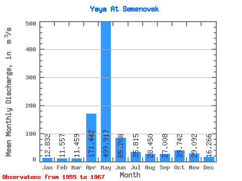
| Statistic | Jan | Feb | Mar | Apr | May | Jun | Jul | Aug | Sep | Oct | Nov | Dec | Annual |
|---|---|---|---|---|---|---|---|---|---|---|---|---|---|
| Mean | 12.83 | 11.56 | 11.46 | 171.44 | 499.92 | 85.21 | 35.81 | 28.45 | 27.01 | 39.74 | 29.09 | 16.27 | 82.66 |
| Standard Deviation | 3.06 | 2.08 | 1.91 | 135.87 | 194.22 | 53.57 | 17.31 | 13.23 | 12.78 | 23.23 | 13.07 | 5.33 | 16.23 |
| Min | 7.86 | 8.56 | 8.60 | 24.00 | 196.00 | 32.20 | 17.30 | 13.00 | 12.40 | 13.00 | 12.60 | 9.59 | 64.13 |
| Max | 18.50 | 14.50 | 14.60 | 549.00 | 780.00 | 230.00 | 63.50 | 58.10 | 60.20 | 92.70 | 51.20 | 29.60 | 116.58 |
| Coefficient of Variation | 0.24 | 0.18 | 0.17 | 0.79 | 0.39 | 0.63 | 0.48 | 0.47 | 0.47 | 0.58 | 0.45 | 0.33 | 0.20 |
 Return to R-Arctic Net Home Page