|
|
|||||||||||||||||
| Point ID: 8463 | Downloads | Plots | Site Data | Code: 10237 |
|
|
|||||||||||||||||
| Download | |
|---|---|
| Site Descriptor Information | Site Time Series Data |
| Link to all available data | |
| View: | Time Series | All |
| Units: | m3/s |
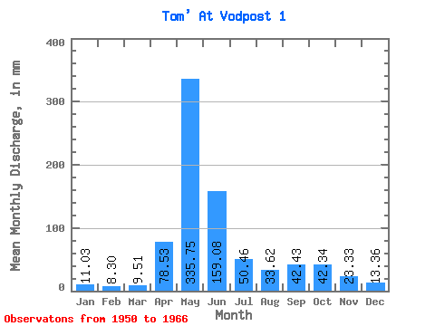
| Statistic | Jan | Feb | Mar | Apr | May | Jun | Jul | Aug | Sep | Oct | Nov | Dec | Annual |
|---|---|---|---|---|---|---|---|---|---|---|---|---|---|
| Mean | 11.03 | 8.37 | 9.51 | 78.53 | 335.70 | 159.08 | 50.45 | 33.61 | 42.43 | 42.33 | 23.33 | 13.36 | 809.28 |
| Standard Deviation | 1.89 | 1.23 | 1.63 | 42.90 | 55.34 | 103.39 | 28.73 | 8.98 | 25.41 | 15.75 | 12.66 | 4.08 | 142.46 |
| Min | 7.99 | 6.51 | 7.63 | 26.31 | 254.28 | 59.56 | 20.96 | 20.15 | 19.24 | 22.05 | 13.09 | 7.11 | 595.26 |
| Max | 13.51 | 10.60 | 12.58 | 151.85 | 443.63 | 361.31 | 113.48 | 50.18 | 82.21 | 65.19 | 50.14 | 21.91 | 1042.41 |
| Coefficient of Variation | 0.17 | 0.15 | 0.17 | 0.55 | 0.17 | 0.65 | 0.57 | 0.27 | 0.60 | 0.37 | 0.54 | 0.30 | 0.18 |
 Return to R-Arctic Net Home Page