|
|
|||||||||||||||||
| Point ID: 8455 | Downloads | Plots | Site Data | Code: 10206 |
|
|
|||||||||||||||||
| Download | |
|---|---|
| Site Descriptor Information | Site Time Series Data |
| Link to all available data | |
| View: | Time Series | All |
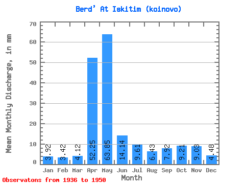
| Units: | m3/s |
| Statistic | Jan | Feb | Mar | Apr | May | Jun | Jul | Aug | Sep | Oct | Nov | Dec | Annual |
|---|---|---|---|---|---|---|---|---|---|---|---|---|---|
| Mean | 3.92 | 3.45 | 4.12 | 52.25 | 63.84 | 14.14 | 9.61 | 6.43 | 7.92 | 9.21 | 9.03 | 4.47 | 188.06 |
| Standard Deviation | 1.27 | 1.05 | 1.25 | 26.16 | 45.60 | 7.12 | 3.86 | 1.91 | 5.39 | 4.62 | 4.99 | 1.36 | 48.51 |
| Min | 1.81 | 1.43 | 1.31 | 5.46 | 14.94 | 3.91 | 3.14 | 2.27 | 1.45 | 1.93 | 3.14 | 2.40 | 97.69 |
| Max | 6.55 | 4.73 | 6.30 | 97.07 | 156.01 | 26.96 | 19.15 | 9.75 | 23.26 | 18.18 | 20.43 | 7.04 | 245.01 |
| Coefficient of Variation | 0.32 | 0.30 | 0.30 | 0.50 | 0.71 | 0.50 | 0.40 | 0.30 | 0.68 | 0.50 | 0.55 | 0.30 | 0.26 |
 Return to R-Arctic Net Home Page