|
|
|||||||||||||||||
| Point ID: 8455 | Downloads | Plots | Site Data | Code: 10206 |
|
|
|||||||||||||||||
| Download | |
|---|---|
| Site Descriptor Information | Site Time Series Data |
| Link to all available data | |
| View: | Time Series | All |
| Units: | mm |
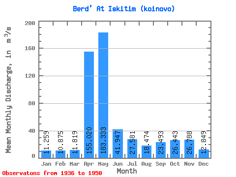
| Statistic | Jan | Feb | Mar | Apr | May | Jun | Jul | Aug | Sep | Oct | Nov | Dec | Annual |
|---|---|---|---|---|---|---|---|---|---|---|---|---|---|
| Mean | 11.26 | 10.88 | 11.82 | 155.02 | 183.33 | 41.95 | 27.58 | 18.47 | 23.49 | 26.44 | 26.79 | 12.85 | 45.82 |
| Standard Deviation | 3.63 | 3.30 | 3.58 | 77.60 | 130.95 | 21.12 | 11.09 | 5.47 | 15.99 | 13.28 | 14.81 | 3.89 | 11.82 |
| Min | 5.19 | 4.52 | 3.77 | 16.20 | 42.90 | 11.60 | 9.01 | 6.51 | 4.30 | 5.55 | 9.32 | 6.90 | 23.80 |
| Max | 18.80 | 14.90 | 18.10 | 288.00 | 448.00 | 80.00 | 55.00 | 28.00 | 69.00 | 52.20 | 60.60 | 20.20 | 59.70 |
| Coefficient of Variation | 0.32 | 0.30 | 0.30 | 0.50 | 0.71 | 0.50 | 0.40 | 0.30 | 0.68 | 0.50 | 0.55 | 0.30 | 0.26 |
 Return to R-Arctic Net Home Page