|
|
|||||||||||||||||
| Point ID: 8344 | Downloads | Plots | Site Data | Code: 9307 |
|
|
|||||||||||||||||
| Download | |
|---|---|
| Site Descriptor Information | Site Time Series Data |
| Link to all available data | |
| View: | Time Series | All |
| Units: | m3/s |
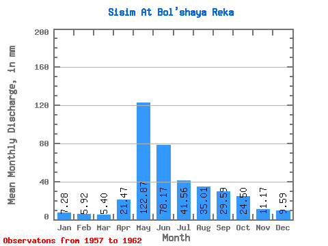
| Statistic | Jan | Feb | Mar | Apr | May | Jun | Jul | Aug | Sep | Oct | Nov | Dec | Annual |
|---|---|---|---|---|---|---|---|---|---|---|---|---|---|
| Mean | 7.28 | 5.97 | 5.40 | 21.47 | 122.85 | 78.17 | 41.55 | 35.01 | 29.59 | 24.50 | 11.17 | 9.59 | 390.67 |
| Standard Deviation | 1.32 | 1.56 | 1.43 | 10.18 | 11.19 | 21.85 | 14.10 | 18.04 | 10.65 | 6.83 | 4.70 | 3.45 | 41.90 |
| Min | 6.12 | 4.15 | 3.03 | 10.22 | 105.55 | 45.68 | 27.04 | 19.71 | 17.14 | 15.35 | 6.35 | 6.34 | 337.21 |
| Max | 9.77 | 8.58 | 6.78 | 37.74 | 136.95 | 103.00 | 67.25 | 65.34 | 45.00 | 34.02 | 19.33 | 16.14 | 455.98 |
| Coefficient of Variation | 0.18 | 0.26 | 0.27 | 0.47 | 0.09 | 0.28 | 0.34 | 0.52 | 0.36 | 0.28 | 0.42 | 0.36 | 0.11 |
 Return to R-Arctic Net Home Page