|
|
|||||||||||||||||
| Point ID: 8344 | Downloads | Plots | Site Data | Code: 9307 |
|
|
|||||||||||||||||
| Download | |
|---|---|
| Site Descriptor Information | Site Time Series Data |
| Link to all available data | |
|
|
| View: | Statistics | Time Series |
| Units: | m3/s |
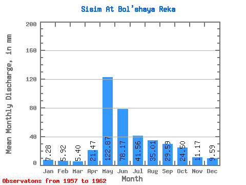
| Statistic | Jan | Feb | Mar | Apr | May | Jun | Jul | Aug | Sep | Oct | Nov | Dec | Annual |
|---|---|---|---|---|---|---|---|---|---|---|---|---|---|
| Mean | 7.28 | 5.97 | 5.40 | 21.47 | 122.85 | 78.17 | 41.55 | 35.01 | 29.59 | 24.50 | 11.17 | 9.59 | 390.67 |
| Standard Deviation | 1.32 | 1.56 | 1.43 | 10.18 | 11.19 | 21.85 | 14.10 | 18.04 | 10.65 | 6.83 | 4.70 | 3.45 | 41.90 |
| Min | 6.12 | 4.15 | 3.03 | 10.22 | 105.55 | 45.68 | 27.04 | 19.71 | 17.14 | 15.35 | 6.35 | 6.34 | 337.21 |
| Max | 9.77 | 8.58 | 6.78 | 37.74 | 136.95 | 103.00 | 67.25 | 65.34 | 45.00 | 34.02 | 19.33 | 16.14 | 455.98 |
| Coefficient of Variation | 0.18 | 0.26 | 0.27 | 0.47 | 0.09 | 0.28 | 0.34 | 0.52 | 0.36 | 0.28 | 0.42 | 0.36 | 0.11 |
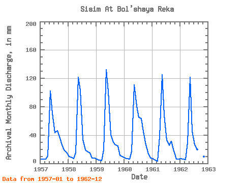
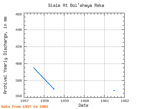
| Year | Jan | Feb | Mar | Apr | May | Jun | Jul | Aug | Sep | Oct | Nov | Dec | Annual | 1957 | 6.12 | 6.07 | 6.12 | 10.22 | 105.55 | 70.50 | 44.66 | 47.89 | 37.83 | 26.87 | 19.33 | 16.14 | 395.25 | 1958 | 9.77 | 8.58 | 6.78 | 15.28 | 125.61 | 103.00 | 34.28 | 19.71 | 17.14 | 15.35 | 7.59 | 8.11 | 370.05 | 1959 | 6.66 | 4.64 | 4.33 | 19.00 | 136.95 | 101.32 | 42.22 | 30.44 | 26.51 | 25.91 | 11.14 | 10.03 | 417.24 | 1960 | 7.67 | 6.46 | 6.33 | 17.14 | 114.27 | 80.97 | 67.25 | 65.34 | 45.00 | 27.04 | 13.26 | 7.75 | 455.98 | 1961 | 6.72 | 4.15 | 3.03 | 37.74 | 129.10 | 67.54 | 33.85 | 26.00 | 31.24 | 17.80 | 6.35 | 6.34 | 368.27 | 1962 | 6.75 | 5.92 | 5.79 | 29.47 | 125.61 | 45.68 | 27.04 | 20.67 | 19.84 | 34.02 | 9.37 | 9.16 | 337.21 |
|---|
 Return to R-Arctic Net Home Page