|
|
|||||||||||||||||
| Point ID: 8343 | Downloads | Plots | Site Data | Code: 9305 |
|
|
|||||||||||||||||
| Download | |
|---|---|
| Site Descriptor Information | Site Time Series Data |
| Link to all available data | |
| View: | Time Series | All |
| Units: | m3/s |
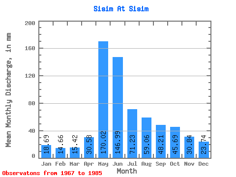
| Statistic | Jan | Feb | Mar | Apr | May | Jun | Jul | Aug | Sep | Oct | Nov | Dec | Annual |
|---|---|---|---|---|---|---|---|---|---|---|---|---|---|
| Mean | 18.68 | 14.79 | 15.42 | 30.59 | 170.00 | 146.98 | 71.23 | 59.05 | 48.21 | 45.68 | 30.84 | 23.74 | 672.87 |
| Standard Deviation | 3.70 | 3.15 | 3.47 | 13.57 | 29.35 | 71.89 | 25.47 | 22.56 | 15.50 | 12.84 | 8.10 | 5.19 | 120.61 |
| Min | 11.75 | 8.96 | 7.01 | 12.70 | 112.04 | 57.57 | 40.72 | 27.69 | 27.15 | 23.50 | 15.34 | 15.21 | 412.48 |
| Max | 22.95 | 19.67 | 21.86 | 57.48 | 227.72 | 284.77 | 118.42 | 112.95 | 86.05 | 71.14 | 45.84 | 30.88 | 878.72 |
| Coefficient of Variation | 0.20 | 0.21 | 0.23 | 0.44 | 0.17 | 0.49 | 0.36 | 0.38 | 0.32 | 0.28 | 0.26 | 0.22 | 0.18 |
 Return to R-Arctic Net Home Page