|
|
|||||||||||||||||
| Point ID: 8343 | Downloads | Plots | Site Data | Code: 9305 |
|
|
|||||||||||||||||
| Download | |
|---|---|
| Site Descriptor Information | Site Time Series Data |
| Link to all available data | |
|
|
| View: | Statistics | Time Series |
| Units: | m3/s |
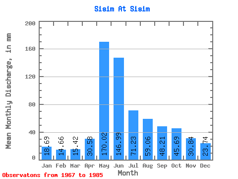
| Statistic | Jan | Feb | Mar | Apr | May | Jun | Jul | Aug | Sep | Oct | Nov | Dec | Annual |
|---|---|---|---|---|---|---|---|---|---|---|---|---|---|
| Mean | 18.68 | 14.79 | 15.42 | 30.59 | 170.00 | 146.98 | 71.23 | 59.05 | 48.21 | 45.68 | 30.84 | 23.74 | 672.87 |
| Standard Deviation | 3.70 | 3.15 | 3.47 | 13.57 | 29.35 | 71.89 | 25.47 | 22.56 | 15.50 | 12.84 | 8.10 | 5.19 | 120.61 |
| Min | 11.75 | 8.96 | 7.01 | 12.70 | 112.04 | 57.57 | 40.72 | 27.69 | 27.15 | 23.50 | 15.34 | 15.21 | 412.48 |
| Max | 22.95 | 19.67 | 21.86 | 57.48 | 227.72 | 284.77 | 118.42 | 112.95 | 86.05 | 71.14 | 45.84 | 30.88 | 878.72 |
| Coefficient of Variation | 0.20 | 0.21 | 0.23 | 0.44 | 0.17 | 0.49 | 0.36 | 0.38 | 0.32 | 0.28 | 0.26 | 0.22 | 0.18 |
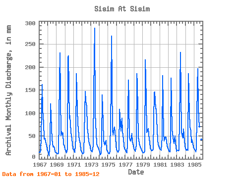
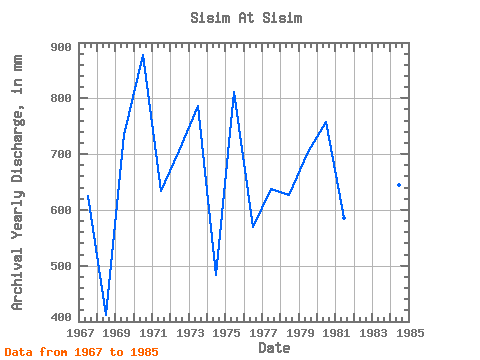
| Year | Jan | Feb | Mar | Apr | May | Jun | Jul | Aug | Sep | Oct | Nov | Dec | Annual | 1967 | 14.57 | 13.61 | 18.95 | 46.81 | 167.60 | 106.68 | 80.34 | 44.54 | 44.70 | 38.35 | 29.98 | 21.59 | 625.21 | 1968 | 15.94 | 11.29 | 7.01 | 36.85 | 123.88 | 66.83 | 43.36 | 27.69 | 27.15 | 23.50 | 15.34 | 15.21 | 412.48 | 1969 | 13.48 | 10.96 | 11.39 | 12.70 | 173.07 | 230.99 | 52.74 | 61.48 | 52.10 | 58.21 | 31.30 | 28.51 | 735.42 | 1970 | 21.86 | 15.27 | 14.30 | 21.25 | 227.72 | 223.94 | 92.00 | 97.47 | 58.28 | 53.20 | 33.77 | 23.05 | 878.72 | 1971 | 21.59 | 14.77 | 14.76 | 44.52 | 192.20 | 107.56 | 78.97 | 52.65 | 40.91 | 34.07 | 19.04 | 16.03 | 633.97 | 1972 | 11.75 | 10.29 | 13.39 | 57.48 | 152.12 | 125.19 | 118.42 | 71.69 | 51.31 | 39.72 | 30.59 | 27.60 | 706.43 | 1973 | 19.58 | 16.10 | 16.30 | 28.39 | 151.21 | 284.77 | 102.93 | 56.84 | 33.94 | 29.24 | 24.77 | 23.14 | 786.76 | 1974 | 16.58 | 8.96 | 12.84 | 38.00 | 143.92 | 81.11 | 41.35 | 31.24 | 33.85 | 42.08 | 19.40 | 16.30 | 483.42 | 1975 | 14.39 | 11.12 | 12.39 | 16.57 | 158.49 | 267.13 | 66.40 | 53.92 | 66.30 | 71.14 | 45.84 | 28.97 | 812.08 | 1976 | 20.77 | 15.69 | 15.12 | 19.75 | 112.04 | 78.99 | 62.58 | 92.00 | 59.60 | 44.00 | 29.18 | 22.23 | 569.30 | 1977 | 20.86 | 16.18 | 13.94 | 31.47 | 177.62 | 126.95 | 48.09 | 40.53 | 39.06 | 57.66 | 37.56 | 29.97 | 637.65 | 1978 | 22.86 | 17.26 | 16.67 | 29.62 | 192.20 | 163.98 | 49.92 | 41.90 | 28.48 | 27.05 | 21.42 | 18.13 | 627.80 | 1979 | 13.57 | 12.45 | 13.94 | 17.10 | 222.26 | 132.25 | 59.66 | 63.94 | 66.30 | 44.27 | 36.32 | 24.96 | 703.75 | 1980 | 19.22 | 17.10 | 19.49 | 21.86 | 149.38 | 145.47 | 112.95 | 112.95 | 63.65 | 41.35 | 31.83 | 25.60 | 757.42 | 1981 | 22.95 | 19.67 | 19.86 | 46.73 | 186.73 | 57.57 | 40.72 | 44.45 | 47.96 | 47.64 | 30.06 | 24.50 | 586.11 | 1982 | 20.31 | 15.44 | 15.85 | 51.84 | 182.18 | 64.27 | 57.20 | 38.90 | 33.77 | 52.01 | 33.94 | 16.94 | 579.67 | 1983 | 19.49 | 18.09 | 18.49 | 18.95 | 161.23 | 231.87 | 61.03 | 54.84 | 46.20 | 67.68 | 40.47 | 29.79 | 767.08 | 1984 | 22.95 | 17.76 | 21.86 | 18.87 | 191.29 | 100.51 | 72.60 | 62.49 | 36.32 | 43.45 | 33.24 | 27.69 | 645.25 | 1985 | 22.13 | 18.92 | 16.40 | 22.39 | 164.87 | 196.60 | 112.04 | 72.42 | 86.05 | 53.29 | 41.97 | 30.88 | 836.05 |
|---|
 Return to R-Arctic Net Home Page