|
|
|||||||||||||||||
| Point ID: 8334 | Downloads | Plots | Site Data | Code: 9293 |
|
|
|||||||||||||||||
| Download | |
|---|---|
| Site Descriptor Information | Site Time Series Data |
| Link to all available data | |
| View: | Time Series | All |
| Units: | m3/s |
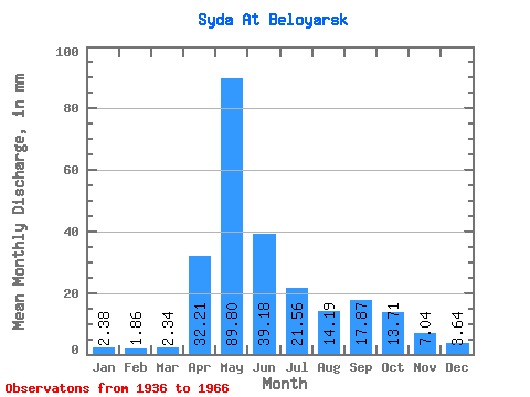
| Statistic | Jan | Feb | Mar | Apr | May | Jun | Jul | Aug | Sep | Oct | Nov | Dec | Annual |
|---|---|---|---|---|---|---|---|---|---|---|---|---|---|
| Mean | 2.38 | 1.88 | 2.34 | 32.21 | 89.79 | 39.18 | 21.56 | 14.19 | 17.87 | 13.71 | 7.04 | 3.64 | 249.00 |
| Standard Deviation | 0.70 | 0.66 | 1.03 | 20.85 | 31.56 | 23.41 | 11.05 | 7.74 | 12.99 | 7.17 | 5.18 | 1.52 | 57.11 |
| Min | 1.11 | 0.66 | 0.96 | 2.78 | 22.10 | 9.70 | 6.79 | 5.33 | 6.13 | 4.44 | 2.38 | 1.30 | 151.31 |
| Max | 4.12 | 3.23 | 5.04 | 77.84 | 164.29 | 124.83 | 61.20 | 34.83 | 55.18 | 31.30 | 29.18 | 6.64 | 415.24 |
| Coefficient of Variation | 0.29 | 0.35 | 0.44 | 0.65 | 0.35 | 0.60 | 0.51 | 0.55 | 0.73 | 0.52 | 0.74 | 0.42 | 0.23 |
 Return to R-Arctic Net Home Page