|
|
|||||||||||||||||
| Point ID: 8334 | Downloads | Plots | Site Data | Code: 9293 |
|
|
|||||||||||||||||
| Download | |
|---|---|
| Site Descriptor Information | Site Time Series Data |
| Link to all available data | |
| View: | Time Series | All |
| Units: | mm |
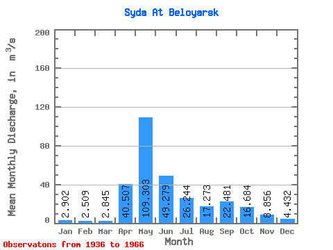
| Statistic | Jan | Feb | Mar | Apr | May | Jun | Jul | Aug | Sep | Oct | Nov | Dec | Annual |
|---|---|---|---|---|---|---|---|---|---|---|---|---|---|
| Mean | 2.90 | 2.51 | 2.84 | 40.51 | 109.30 | 49.28 | 26.24 | 17.27 | 22.48 | 16.68 | 8.86 | 4.43 | 25.72 |
| Standard Deviation | 0.85 | 0.89 | 1.25 | 26.22 | 38.42 | 29.45 | 13.45 | 9.43 | 16.34 | 8.72 | 6.52 | 1.86 | 5.90 |
| Min | 1.35 | 0.88 | 1.17 | 3.50 | 26.90 | 12.20 | 8.26 | 6.49 | 7.71 | 5.40 | 3.00 | 1.58 | 15.63 |
| Max | 5.02 | 4.31 | 6.14 | 97.90 | 200.00 | 157.00 | 74.50 | 42.40 | 69.40 | 38.10 | 36.70 | 8.08 | 42.89 |
| Coefficient of Variation | 0.29 | 0.35 | 0.44 | 0.65 | 0.35 | 0.60 | 0.51 | 0.55 | 0.73 | 0.52 | 0.74 | 0.42 | 0.23 |
 Return to R-Arctic Net Home Page