|
|
|||||||||||||||||
| Point ID: 8325 | Downloads | Plots | Site Data | Code: 9254 |
|
|
|||||||||||||||||
| Download | |
|---|---|
| Site Descriptor Information | Site Time Series Data |
| Link to all available data | |
| View: | Time Series | All |
| Units: | m3/s |
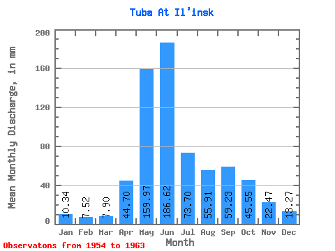
| Statistic | Jan | Feb | Mar | Apr | May | Jun | Jul | Aug | Sep | Oct | Nov | Dec | Annual |
|---|---|---|---|---|---|---|---|---|---|---|---|---|---|
| Mean | 10.34 | 7.59 | 7.89 | 44.70 | 159.95 | 186.62 | 73.69 | 55.90 | 59.23 | 45.54 | 22.47 | 13.26 | 685.26 |
| Standard Deviation | 1.43 | 0.91 | 1.36 | 19.38 | 41.13 | 34.27 | 14.99 | 21.43 | 23.59 | 11.74 | 8.40 | 1.44 | 60.51 |
| Min | 8.80 | 6.30 | 5.96 | 23.01 | 79.24 | 132.09 | 54.22 | 34.70 | 29.90 | 28.39 | 14.49 | 11.45 | 624.17 |
| Max | 13.21 | 9.09 | 10.05 | 85.93 | 211.31 | 230.08 | 105.65 | 92.45 | 98.71 | 61.34 | 42.82 | 15.78 | 778.62 |
| Coefficient of Variation | 0.14 | 0.12 | 0.17 | 0.43 | 0.26 | 0.18 | 0.20 | 0.38 | 0.40 | 0.26 | 0.37 | 0.11 | 0.09 |
 Return to R-Arctic Net Home Page