|
|
|||||||||||||||||
| Point ID: 8325 | Downloads | Plots | Site Data | Code: 9254 |
|
|
|||||||||||||||||
| Download | |
|---|---|
| Site Descriptor Information | Site Time Series Data |
| Link to all available data | |
| View: | Time Series | All |
| Units: | mm |
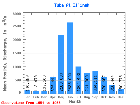
| Statistic | Jan | Feb | Mar | Apr | May | Jun | Jul | Aug | Sep | Oct | Nov | Dec | Annual |
|---|---|---|---|---|---|---|---|---|---|---|---|---|---|
| Mean | 140.89 | 113.48 | 107.60 | 629.44 | 2180.00 | 2628.00 | 1004.40 | 761.89 | 834.11 | 620.67 | 316.44 | 180.78 | 792.53 |
| Standard Deviation | 19.45 | 13.60 | 18.52 | 272.88 | 560.58 | 482.58 | 204.37 | 292.15 | 332.20 | 160.01 | 118.25 | 19.62 | 69.98 |
| Min | 120.00 | 94.30 | 81.30 | 324.00 | 1080.00 | 1860.00 | 739.00 | 473.00 | 421.00 | 387.00 | 204.00 | 156.00 | 721.87 |
| Max | 180.00 | 136.00 | 137.00 | 1210.00 | 2880.00 | 3240.00 | 1440.00 | 1260.00 | 1390.00 | 836.00 | 603.00 | 215.00 | 900.50 |
| Coefficient of Variation | 0.14 | 0.12 | 0.17 | 0.43 | 0.26 | 0.18 | 0.20 | 0.38 | 0.40 | 0.26 | 0.37 | 0.11 | 0.09 |
 Return to R-Arctic Net Home Page