|
|
|||||||||||||||||
| Point ID: 8234 | Downloads | Plots | Site Data | Code: 8282 |
|
|
|||||||||||||||||
| Download | |
|---|---|
| Site Descriptor Information | Site Time Series Data |
| Link to all available data | |
| View: | Time Series | All |
| Units: | m3/s |
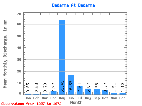
| Statistic | Jan | Feb | Mar | Apr | May | Jun | Jul | Aug | Sep | Oct | Nov | Dec | Annual |
|---|---|---|---|---|---|---|---|---|---|---|---|---|---|
| Mean | 0.85 | 0.63 | 0.70 | 2.97 | 63.42 | 16.59 | 7.64 | 5.07 | 4.98 | 3.76 | 1.52 | 1.10 | 107.93 |
| Standard Deviation | 0.52 | 0.48 | 0.49 | 3.55 | 20.48 | 8.81 | 3.64 | 3.04 | 2.60 | 1.96 | 0.66 | 0.54 | 29.41 |
| Min | 0.25 | 0.10 | 0.08 | 0.35 | 24.70 | 7.07 | 4.02 | 1.42 | 1.48 | 0.81 | 0.40 | 0.30 | 55.18 |
| Max | 2.04 | 1.57 | 1.70 | 11.05 | 98.67 | 33.34 | 15.86 | 12.75 | 11.46 | 8.40 | 2.74 | 2.44 | 157.17 |
| Coefficient of Variation | 0.62 | 0.76 | 0.71 | 1.20 | 0.32 | 0.53 | 0.48 | 0.60 | 0.52 | 0.52 | 0.43 | 0.49 | 0.27 |
 Return to R-Arctic Net Home Page