|
|
|||||||||||||||||
| Point ID: 8234 | Downloads | Plots | Site Data | Code: 8282 |
|
|
|||||||||||||||||
| Download | |
|---|---|
| Site Descriptor Information | Site Time Series Data |
| Link to all available data | |
| View: | Time Series | All |
| Units: | mm |
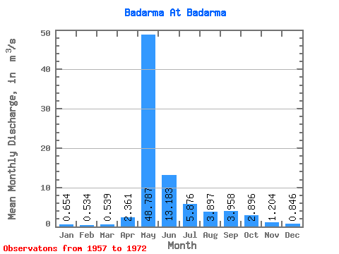
| Statistic | Jan | Feb | Mar | Apr | May | Jun | Jul | Aug | Sep | Oct | Nov | Dec | Annual |
|---|---|---|---|---|---|---|---|---|---|---|---|---|---|
| Mean | 0.65 | 0.53 | 0.54 | 2.36 | 48.79 | 13.18 | 5.88 | 3.90 | 3.96 | 2.90 | 1.20 | 0.85 | 7.04 |
| Standard Deviation | 0.40 | 0.40 | 0.38 | 2.82 | 15.76 | 7.00 | 2.80 | 2.33 | 2.06 | 1.50 | 0.52 | 0.42 | 1.92 |
| Min | 0.19 | 0.09 | 0.06 | 0.28 | 19.00 | 5.62 | 3.09 | 1.09 | 1.18 | 0.62 | 0.32 | 0.23 | 3.60 |
| Max | 1.57 | 1.33 | 1.31 | 8.78 | 75.90 | 26.50 | 12.20 | 9.81 | 9.11 | 6.46 | 2.18 | 1.88 | 10.26 |
| Coefficient of Variation | 0.62 | 0.76 | 0.71 | 1.20 | 0.32 | 0.53 | 0.48 | 0.60 | 0.52 | 0.52 | 0.43 | 0.49 | 0.27 |
 Return to R-Arctic Net Home Page