|
|
|||||||||||||||||
| Point ID: 8188 | Downloads | Plots | Site Data | Code: 8166 |
|
|
|||||||||||||||||
| Download | |
|---|---|
| Site Descriptor Information | Site Time Series Data |
| Link to all available data | |
| View: | Time Series | All |
| Units: | m3/s |
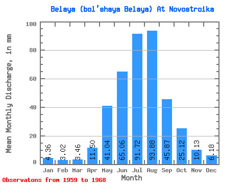
| Statistic | Jan | Feb | Mar | Apr | May | Jun | Jul | Aug | Sep | Oct | Nov | Dec | Annual |
|---|---|---|---|---|---|---|---|---|---|---|---|---|---|
| Mean | 4.36 | 3.04 | 3.46 | 11.50 | 41.03 | 65.06 | 91.70 | 93.87 | 45.87 | 25.11 | 10.13 | 6.18 | 400.74 |
| Standard Deviation | 1.16 | 0.92 | 0.73 | 4.49 | 14.46 | 18.95 | 25.45 | 43.29 | 5.87 | 4.76 | 2.11 | 2.71 | 47.01 |
| Min | 2.74 | 1.93 | 2.52 | 5.21 | 26.29 | 38.52 | 46.80 | 57.76 | 37.48 | 20.02 | 5.71 | 3.08 | 331.18 |
| Max | 5.92 | 4.41 | 4.67 | 17.95 | 64.11 | 96.50 | 126.07 | 206.00 | 57.02 | 34.94 | 12.84 | 11.29 | 456.56 |
| Coefficient of Variation | 0.27 | 0.30 | 0.21 | 0.39 | 0.35 | 0.29 | 0.28 | 0.46 | 0.13 | 0.19 | 0.21 | 0.44 | 0.12 |
 Return to R-Arctic Net Home Page