|
|
|||||||||||||||||
| Point ID: 8188 | Downloads | Plots | Site Data | Code: 8166 |
|
|
|||||||||||||||||
| Download | |
|---|---|
| Site Descriptor Information | Site Time Series Data |
| Link to all available data | |
| View: | Time Series | All |
| Units: | mm |
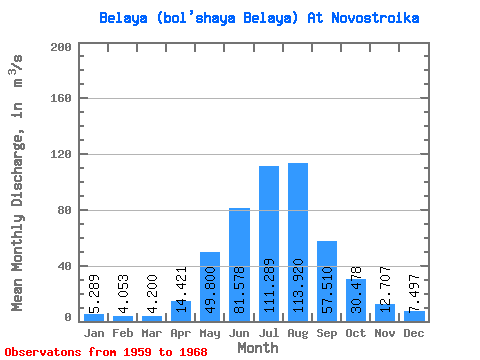
| Statistic | Jan | Feb | Mar | Apr | May | Jun | Jul | Aug | Sep | Oct | Nov | Dec | Annual |
|---|---|---|---|---|---|---|---|---|---|---|---|---|---|
| Mean | 5.29 | 4.05 | 4.20 | 14.42 | 49.80 | 81.58 | 111.29 | 113.92 | 57.51 | 30.48 | 12.71 | 7.50 | 41.27 |
| Standard Deviation | 1.41 | 1.22 | 0.89 | 5.63 | 17.54 | 23.76 | 30.88 | 52.53 | 7.37 | 5.78 | 2.65 | 3.29 | 4.84 |
| Min | 3.33 | 2.57 | 3.06 | 6.53 | 31.90 | 48.30 | 56.80 | 70.10 | 47.00 | 24.30 | 7.16 | 3.74 | 34.10 |
| Max | 7.18 | 5.87 | 5.67 | 22.50 | 77.80 | 121.00 | 153.00 | 250.00 | 71.50 | 42.40 | 16.10 | 13.70 | 47.02 |
| Coefficient of Variation | 0.27 | 0.30 | 0.21 | 0.39 | 0.35 | 0.29 | 0.28 | 0.46 | 0.13 | 0.19 | 0.21 | 0.44 | 0.12 |
 Return to R-Arctic Net Home Page