|
|
|||||||||||||||||
| Point ID: 8094 | Downloads | Plots | Site Data | Code: 1534 |
|
|
|||||||||||||||||
| Download | |
|---|---|
| Site Descriptor Information | Site Time Series Data |
| Link to all available data | |
| View: | Time Series | All |
| Units: | m3/s |
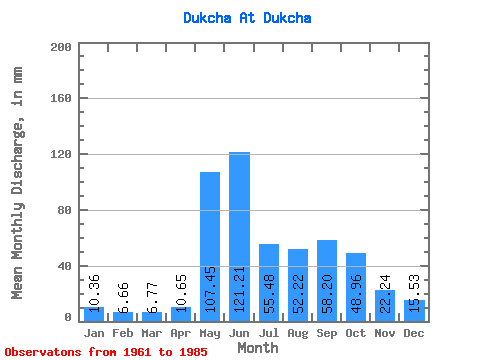
| Statistic | Jan | Feb | Mar | Apr | May | Jun | Jul | Aug | Sep | Oct | Nov | Dec | Annual |
|---|---|---|---|---|---|---|---|---|---|---|---|---|---|
| Mean | 10.36 | 6.72 | 6.77 | 10.65 | 107.44 | 121.21 | 55.48 | 52.21 | 58.21 | 48.95 | 22.23 | 15.52 | 514.06 |
| Standard Deviation | 3.71 | 3.19 | 3.29 | 4.23 | 31.36 | 64.81 | 32.25 | 23.90 | 23.96 | 28.64 | 8.75 | 4.73 | 113.62 |
| Min | 3.81 | 2.29 | 0.18 | 3.30 | 55.83 | 43.44 | 25.64 | 25.16 | 23.88 | 17.37 | 9.66 | 8.36 | 342.78 |
| Max | 17.29 | 13.53 | 15.34 | 21.13 | 173.66 | 298.47 | 166.36 | 105.50 | 113.11 | 140.39 | 45.95 | 26.05 | 779.36 |
| Coefficient of Variation | 0.36 | 0.47 | 0.49 | 0.40 | 0.29 | 0.54 | 0.58 | 0.46 | 0.41 | 0.58 | 0.39 | 0.30 | 0.22 |
 Return to R-Arctic Net Home Page