|
|
|||||||||||||||||
| Point ID: 8094 | Downloads | Plots | Site Data | Code: 1534 |
|
|
|||||||||||||||||
| Download | |
|---|---|
| Site Descriptor Information | Site Time Series Data |
| Link to all available data | |
| View: | Time Series | All |
| Units: | mm |
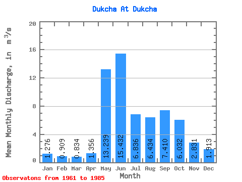
| Statistic | Jan | Feb | Mar | Apr | May | Jun | Jul | Aug | Sep | Oct | Nov | Dec | Annual |
|---|---|---|---|---|---|---|---|---|---|---|---|---|---|
| Mean | 1.28 | 0.91 | 0.83 | 1.36 | 13.24 | 15.43 | 6.84 | 6.43 | 7.41 | 6.03 | 2.83 | 1.91 | 5.38 |
| Standard Deviation | 0.46 | 0.43 | 0.41 | 0.54 | 3.86 | 8.25 | 3.97 | 2.94 | 3.05 | 3.53 | 1.11 | 0.58 | 1.19 |
| Min | 0.47 | 0.31 | 0.02 | 0.42 | 6.88 | 5.53 | 3.16 | 3.10 | 3.04 | 2.14 | 1.23 | 1.03 | 3.58 |
| Max | 2.13 | 1.83 | 1.89 | 2.69 | 21.40 | 38.00 | 20.50 | 13.00 | 14.40 | 17.30 | 5.85 | 3.21 | 8.15 |
| Coefficient of Variation | 0.36 | 0.47 | 0.49 | 0.40 | 0.29 | 0.54 | 0.58 | 0.46 | 0.41 | 0.58 | 0.39 | 0.30 | 0.22 |
 Return to R-Arctic Net Home Page