|
|
|||||||||||||||||
| Point ID: 809 | Downloads | Plots | Site Data | Code: 07OB003 |
|
|
|||||||||||||||||
| Download | |
|---|---|
| Site Descriptor Information | Site Time Series Data |
| Link to all available data | |
| View: | Time Series | All |
| Units: | m3/s |
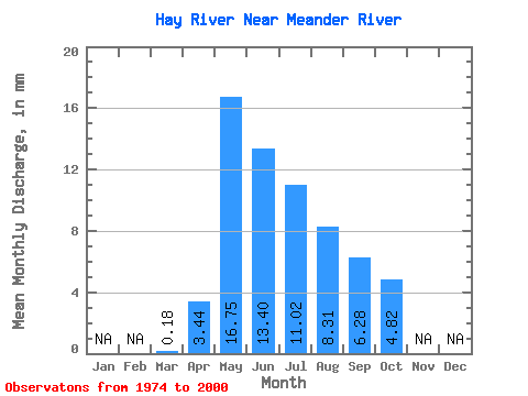
| Statistic | Jan | Feb | Mar | Apr | May | Jun | Jul | Aug | Sep | Oct | Nov | Dec | Annual |
|---|---|---|---|---|---|---|---|---|---|---|---|---|---|
| Mean | 0.18 | 3.44 | 16.74 | 13.40 | 11.02 | 8.31 | 6.28 | 4.82 | |||||
| Standard Deviation | 0.19 | 2.93 | 7.83 | 8.88 | 7.99 | 6.90 | 5.11 | 4.46 | |||||
| Min | 0.01 | 0.05 | 2.08 | 1.52 | 1.52 | 0.62 | 0.31 | 0.22 | |||||
| Max | 0.77 | 10.26 | 33.38 | 43.06 | 31.28 | 30.19 | 20.23 | 20.39 | |||||
| Coefficient of Variation | 1.06 | 0.85 | 0.47 | 0.66 | 0.72 | 0.83 | 0.81 | 0.93 |
 Return to R-Arctic Net Home Page