|
|
|||||||||||||||||
| Point ID: 809 | Downloads | Plots | Site Data | Code: 07OB003 |
|
|
|||||||||||||||||
| Download | |
|---|---|
| Site Descriptor Information | Site Time Series Data |
| Link to all available data | |
| View: | Time Series | All |
| Units: | mm |
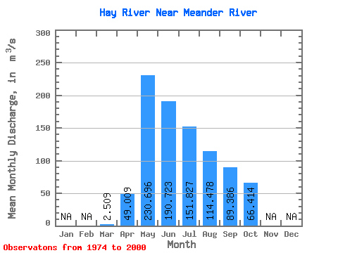
| Statistic | Jan | Feb | Mar | Apr | May | Jun | Jul | Aug | Sep | Oct | Nov | Dec | Annual |
|---|---|---|---|---|---|---|---|---|---|---|---|---|---|
| Mean | 2.51 | 49.01 | 230.70 | 190.72 | 151.83 | 114.48 | 89.39 | 66.41 | |||||
| Standard Deviation | 2.66 | 41.70 | 107.82 | 126.49 | 110.13 | 95.08 | 72.77 | 61.50 | |||||
| Min | 0.14 | 0.77 | 28.60 | 21.60 | 21.00 | 8.52 | 4.36 | 3.08 | |||||
| Max | 10.60 | 146.00 | 460.00 | 613.00 | 431.00 | 416.00 | 288.00 | 281.00 | |||||
| Coefficient of Variation | 1.06 | 0.85 | 0.47 | 0.66 | 0.72 | 0.83 | 0.81 | 0.93 |
 Return to R-Arctic Net Home Page