|
|
|||||||||||||||||
| Point ID: 801 | Downloads | Plots | Site Data | Code: 07KC001 |
|
|
|||||||||||||||||
| Download | |
|---|---|
| Site Descriptor Information | Site Time Series Data |
| Link to all available data | |
| View: | Time Series | All |
| Units: | m3/s |
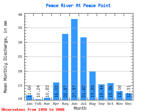
| Statistic | Jan | Feb | Mar | Apr | May | Jun | Jul | Aug | Sep | Oct | Nov | Dec | Annual |
|---|---|---|---|---|---|---|---|---|---|---|---|---|---|
| Mean | 11.66 | 10.32 | 10.83 | 16.03 | 32.87 | 37.98 | 31.61 | 19.82 | 15.44 | 15.86 | 13.08 | 12.31 | 227.24 |
| Standard Deviation | 4.64 | 4.58 | 5.02 | 6.44 | 10.88 | 17.23 | 14.82 | 10.04 | 4.41 | 3.55 | 3.29 | 4.81 | 46.91 |
| Min | 3.28 | 3.26 | 3.14 | 3.66 | 13.07 | 12.21 | 12.71 | 10.05 | 7.11 | 6.85 | 5.87 | 3.70 | 118.83 |
| Max | 19.47 | 17.16 | 18.64 | 29.99 | 62.70 | 86.61 | 79.15 | 52.55 | 27.78 | 24.59 | 20.52 | 19.93 | 366.05 |
| Coefficient of Variation | 0.40 | 0.44 | 0.46 | 0.40 | 0.33 | 0.45 | 0.47 | 0.51 | 0.29 | 0.22 | 0.25 | 0.39 | 0.21 |
 Return to R-Arctic Net Home Page