|
|
|||||||||||||||||
| Point ID: 801 | Downloads | Plots | Site Data | Code: 07KC001 |
|
|
|||||||||||||||||
| Download | |
|---|---|
| Site Descriptor Information | Site Time Series Data |
| Link to all available data | |
| View: | Time Series | All |
| Units: | mm |
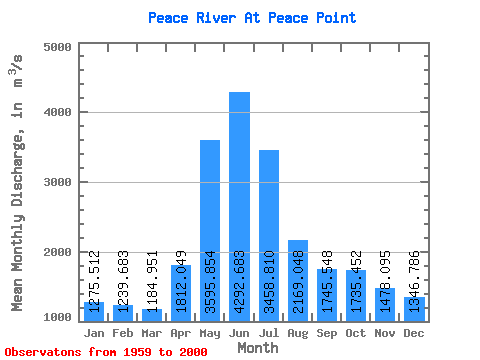
| Statistic | Jan | Feb | Mar | Apr | May | Jun | Jul | Aug | Sep | Oct | Nov | Dec | Annual |
|---|---|---|---|---|---|---|---|---|---|---|---|---|---|
| Mean | 1275.51 | 1239.68 | 1184.95 | 1812.05 | 3595.85 | 4292.68 | 3458.81 | 2169.05 | 1745.55 | 1735.45 | 1478.10 | 1346.79 | 2109.64 |
| Standard Deviation | 507.63 | 550.11 | 548.82 | 727.98 | 1190.48 | 1947.79 | 1621.92 | 1098.26 | 498.74 | 388.05 | 372.15 | 526.21 | 435.50 |
| Min | 359.00 | 392.00 | 344.00 | 414.00 | 1430.00 | 1380.00 | 1390.00 | 1100.00 | 804.00 | 749.00 | 663.00 | 405.00 | 1103.17 |
| Max | 2130.00 | 2060.00 | 2040.00 | 3390.00 | 6860.00 | 9790.00 | 8660.00 | 5750.00 | 3140.00 | 2690.00 | 2320.00 | 2180.00 | 3398.33 |
| Coefficient of Variation | 0.40 | 0.44 | 0.46 | 0.40 | 0.33 | 0.45 | 0.47 | 0.51 | 0.29 | 0.22 | 0.25 | 0.39 | 0.21 |
 Return to R-Arctic Net Home Page