|
|
|||||||||||||||||
| Point ID: 7982 | Downloads | Plots | Site Data | Code: 3627 |
|
|
|||||||||||||||||
| Download | |
|---|---|
| Site Descriptor Information | Site Time Series Data |
| Link to all available data | |
| View: | Time Series | All |
| Units: | m3/s |
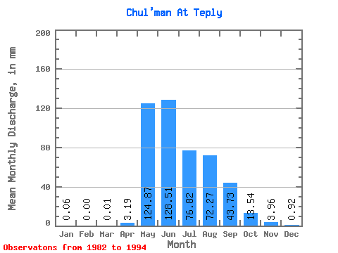
| Statistic | Jan | Feb | Mar | Apr | May | Jun | Jul | Aug | Sep | Oct | Nov | Dec | Annual |
|---|---|---|---|---|---|---|---|---|---|---|---|---|---|
| Mean | 0.06 | 0.00 | 0.01 | 3.19 | 124.85 | 128.51 | 76.81 | 72.26 | 43.73 | 13.53 | 3.96 | 0.92 | 510.08 |
| Standard Deviation | 0.06 | 0.00 | 0.02 | 3.60 | 36.25 | 53.32 | 24.75 | 33.95 | 21.31 | 3.52 | 1.43 | 0.47 | 119.73 |
| Min | 0.00 | 0.00 | 0.00 | 0.16 | 58.06 | 40.95 | 32.18 | 28.58 | 20.69 | 8.16 | 2.00 | 0.05 | 405.84 |
| Max | 0.14 | 0.00 | 0.04 | 11.65 | 180.03 | 196.03 | 114.77 | 137.28 | 82.12 | 20.48 | 6.65 | 1.55 | 634.97 |
| Coefficient of Variation | 1.08 | 2.00 | 2.24 | 1.13 | 0.29 | 0.41 | 0.32 | 0.47 | 0.49 | 0.26 | 0.36 | 0.52 | 0.23 |
 Return to R-Arctic Net Home Page