|
|
|||||||||||||||||
| Point ID: 7982 | Downloads | Plots | Site Data | Code: 3627 |
|
|
|||||||||||||||||
| Download | |
|---|---|
| Site Descriptor Information | Site Time Series Data |
| Link to all available data | |
| View: | Time Series | All |
| Units: | mm |
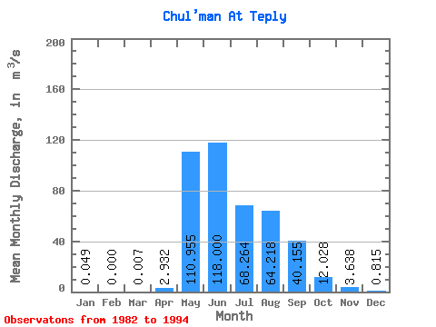
| Statistic | Jan | Feb | Mar | Apr | May | Jun | Jul | Aug | Sep | Oct | Nov | Dec | Annual |
|---|---|---|---|---|---|---|---|---|---|---|---|---|---|
| Mean | 0.05 | 0.00 | 0.01 | 2.93 | 110.95 | 118.00 | 68.26 | 64.22 | 40.16 | 12.03 | 3.64 | 0.81 | 38.47 |
| Standard Deviation | 0.05 | 0.00 | 0.02 | 3.30 | 32.21 | 48.96 | 21.99 | 30.17 | 19.56 | 3.13 | 1.31 | 0.42 | 9.03 |
| Min | 0.00 | 0.00 | 0.00 | 0.15 | 51.60 | 37.60 | 28.60 | 25.40 | 19.00 | 7.25 | 1.84 | 0.04 | 30.61 |
| Max | 0.12 | 0.00 | 0.04 | 10.70 | 160.00 | 180.00 | 102.00 | 122.00 | 75.40 | 18.20 | 6.11 | 1.38 | 47.88 |
| Coefficient of Variation | 1.08 | 2.00 | 2.24 | 1.13 | 0.29 | 0.41 | 0.32 | 0.47 | 0.49 | 0.26 | 0.36 | 0.52 | 0.23 |
 Return to R-Arctic Net Home Page