|
|
|||||||||||||||||
| Point ID: 7912 | Downloads | Plots | Site Data | Code: 3435 |
|
|
|||||||||||||||||
| Download | |
|---|---|
| Site Descriptor Information | Site Time Series Data |
| Link to all available data | |
| View: | Time Series | All |
| Units: | m3/s |
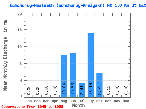
| Statistic | Jan | Feb | Mar | Apr | May | Jun | Jul | Aug | Sep | Oct | Nov | Dec | Annual |
|---|---|---|---|---|---|---|---|---|---|---|---|---|---|
| Mean | 0.00 | 0.00 | 0.00 | 0.00 | 10.02 | 10.56 | 3.41 | 15.16 | 5.79 | 0.12 | 0.00 | 0.00 | 44.79 |
| Standard Deviation | 0.00 | 0.00 | 0.00 | 0.00 | 11.16 | 11.03 | 3.24 | 26.11 | 5.70 | 0.24 | 0.00 | 0.00 | 41.52 |
| Min | 0.00 | 0.00 | 0.00 | 0.00 | 1.85 | 2.02 | 0.54 | 0.00 | 0.35 | 0.00 | 0.00 | 0.00 | 9.74 |
| Max | 0.00 | 0.00 | 0.00 | 0.00 | 31.08 | 30.66 | 8.97 | 67.55 | 12.73 | 0.60 | 0.00 | 0.00 | 112.60 |
| Coefficient of Variation | 1.11 | 1.04 | 0.95 | 1.72 | 0.98 | 2.00 | 0.93 |
 Return to R-Arctic Net Home Page