|
|
|||||||||||||||||
| Point ID: 7912 | Downloads | Plots | Site Data | Code: 3435 |
|
|
|||||||||||||||||
| Download | |
|---|---|
| Site Descriptor Information | Site Time Series Data |
| Link to all available data | |
|
|
| View: | Statistics | Time Series |
| Units: | m3/s |
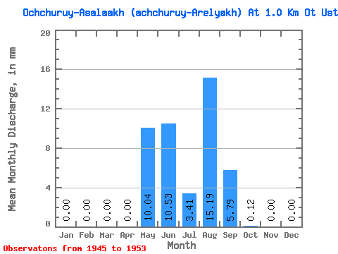
| Statistic | Jan | Feb | Mar | Apr | May | Jun | Jul | Aug | Sep | Oct | Nov | Dec | Annual |
|---|---|---|---|---|---|---|---|---|---|---|---|---|---|
| Mean | 0.00 | 0.00 | 0.00 | 0.00 | 10.02 | 10.56 | 3.41 | 15.16 | 5.79 | 0.12 | 0.00 | 0.00 | 44.79 |
| Standard Deviation | 0.00 | 0.00 | 0.00 | 0.00 | 11.16 | 11.03 | 3.24 | 26.11 | 5.70 | 0.24 | 0.00 | 0.00 | 41.52 |
| Min | 0.00 | 0.00 | 0.00 | 0.00 | 1.85 | 2.02 | 0.54 | 0.00 | 0.35 | 0.00 | 0.00 | 0.00 | 9.74 |
| Max | 0.00 | 0.00 | 0.00 | 0.00 | 31.08 | 30.66 | 8.97 | 67.55 | 12.73 | 0.60 | 0.00 | 0.00 | 112.60 |
| Coefficient of Variation | 1.11 | 1.04 | 0.95 | 1.72 | 0.98 | 2.00 | 0.93 |
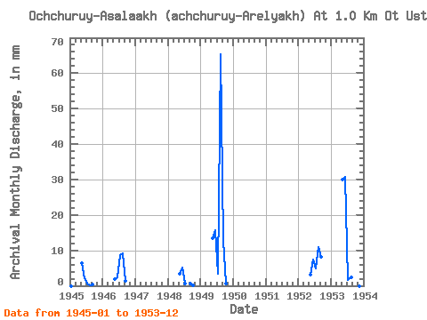
| Year | Jan | Feb | Mar | Apr | May | Jun | Jul | Aug | Sep | Oct | Nov | Dec | Annual | 1945 | 0.00 | 0.00 | 0.00 | 0.00 | 6.58 | 2.02 | 0.72 | 0.18 | 0.35 | 0.00 | 0.00 | 0.00 | 9.74 | 1946 | 0.00 | 0.00 | 0.00 | 0.00 | 1.85 | 2.43 | 8.97 | 9.56 | 1.33 | 0.00 | 0.00 | 0.00 | 23.83 | 1948 | 0.00 | 0.00 | 0.00 | 0.00 | 3.53 | 5.09 | 0.54 | 0.00 | 0.69 | 0.12 | 0.00 | 0.00 | 9.98 | 1949 | 0.00 | 0.00 | 0.00 | 0.00 | 13.75 | 15.62 | 3.47 | 67.55 | 12.73 | 0.60 | 0.00 | 0.00 | 112.60 | 1952 | 0.00 | 0.00 | 0.00 | 0.00 | 3.35 | 7.52 | 5.14 | 11.36 | 8.10 | 0.00 | 0.00 | 0.00 | 35.34 | 1953 | 0.00 | 0.00 | 0.00 | 0.00 | 31.08 | 30.66 | 1.61 | 2.33 | 11.57 | 0.00 | 0.00 | 0.00 | 77.26 |
|---|
 Return to R-Arctic Net Home Page