|
|
|||||||||||||||||
| Point ID: 7807 | Downloads | Plots | Site Data | Code: 3118 |
|
|
|||||||||||||||||
| Download | |
|---|---|
| Site Descriptor Information | Site Time Series Data |
| Link to all available data | |
| View: | Time Series | All |
| Units: | m3/s |
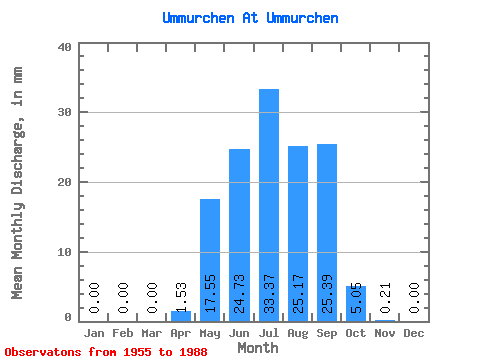
| Statistic | Jan | Feb | Mar | Apr | May | Jun | Jul | Aug | Sep | Oct | Nov | Dec | Annual |
|---|---|---|---|---|---|---|---|---|---|---|---|---|---|
| Mean | 0.00 | 0.00 | 0.00 | 1.53 | 17.55 | 24.73 | 33.37 | 25.17 | 25.39 | 5.05 | 0.21 | 0.00 | 133.50 |
| Standard Deviation | 0.00 | 0.00 | 0.00 | 2.29 | 16.18 | 24.93 | 30.82 | 25.67 | 20.43 | 2.96 | 0.21 | 0.00 | 68.16 |
| Min | 0.00 | 0.00 | 0.00 | 0.00 | 0.33 | 1.41 | 1.51 | 1.71 | 0.88 | 0.50 | 0.02 | 0.00 | 19.26 |
| Max | 0.00 | 0.00 | 0.00 | 8.64 | 61.55 | 91.60 | 103.36 | 91.95 | 94.84 | 10.81 | 1.08 | 0.02 | 284.49 |
| Coefficient of Variation | 1.50 | 0.92 | 1.01 | 0.92 | 1.02 | 0.81 | 0.59 | 1.01 | 3.25 | 0.51 |
 Return to R-Arctic Net Home Page