|
|
|||||||||||||||||
| Point ID: 7807 | Downloads | Plots | Site Data | Code: 3118 |
|
|
|||||||||||||||||
| Download | |
|---|---|
| Site Descriptor Information | Site Time Series Data |
| Link to all available data | |
| View: | Time Series | All |
| Units: | mm |
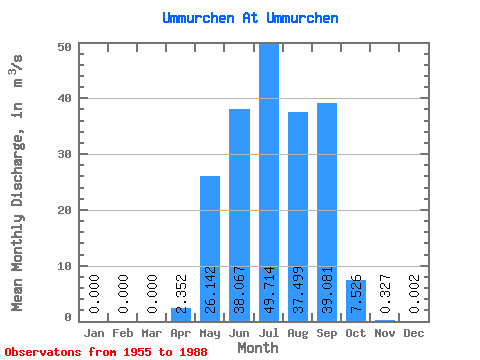
| Statistic | Jan | Feb | Mar | Apr | May | Jun | Jul | Aug | Sep | Oct | Nov | Dec | Annual |
|---|---|---|---|---|---|---|---|---|---|---|---|---|---|
| Mean | 0.00 | 0.00 | 0.00 | 2.35 | 26.14 | 38.07 | 49.71 | 37.50 | 39.08 | 7.53 | 0.33 | 0.00 | 16.88 |
| Standard Deviation | 0.00 | 0.00 | 0.00 | 3.53 | 24.11 | 38.38 | 45.92 | 38.25 | 31.45 | 4.41 | 0.33 | 0.01 | 8.62 |
| Min | 0.00 | 0.00 | 0.00 | 0.00 | 0.49 | 2.17 | 2.25 | 2.55 | 1.36 | 0.74 | 0.02 | 0.00 | 2.43 |
| Max | 0.00 | 0.00 | 0.00 | 13.30 | 91.70 | 141.00 | 154.00 | 137.00 | 146.00 | 16.10 | 1.66 | 0.03 | 35.97 |
| Coefficient of Variation | 1.50 | 0.92 | 1.01 | 0.92 | 1.02 | 0.81 | 0.59 | 1.01 | 3.25 | 0.51 |
 Return to R-Arctic Net Home Page