|
|
|||||||||||||||||
| Point ID: 7795 | Downloads | Plots | Site Data | Code: 3070 |
|
|
|||||||||||||||||
| Download | |
|---|---|
| Site Descriptor Information | Site Time Series Data |
| Link to all available data | |
| View: | Time Series | All |
| Units: | m3/s |
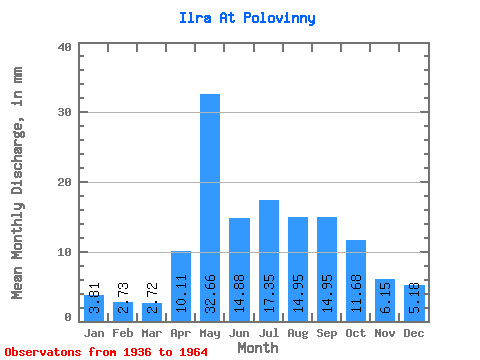
| Statistic | Jan | Feb | Mar | Apr | May | Jun | Jul | Aug | Sep | Oct | Nov | Dec | Annual |
|---|---|---|---|---|---|---|---|---|---|---|---|---|---|
| Mean | 3.81 | 2.75 | 2.72 | 10.11 | 32.66 | 14.88 | 17.34 | 14.95 | 14.95 | 11.68 | 6.14 | 5.17 | 136.06 |
| Standard Deviation | 2.10 | 1.47 | 1.49 | 9.12 | 15.62 | 10.98 | 12.88 | 9.68 | 10.38 | 6.51 | 3.18 | 2.80 | 56.57 |
| Min | 0.53 | 0.43 | 0.32 | 1.44 | 7.43 | 6.29 | 3.53 | 4.14 | 3.17 | 2.90 | 1.39 | 1.14 | 54.43 |
| Max | 8.21 | 5.39 | 5.32 | 32.89 | 62.58 | 54.05 | 48.45 | 44.74 | 39.08 | 24.76 | 11.43 | 10.90 | 270.86 |
| Coefficient of Variation | 0.55 | 0.54 | 0.55 | 0.90 | 0.48 | 0.74 | 0.74 | 0.65 | 0.69 | 0.56 | 0.52 | 0.54 | 0.42 |
 Return to R-Arctic Net Home Page